TauTona Mine – World’s Deepest Mine

http://pagead2.googlesyndication.com/pagead/show_ads.js

The TauTona Mine or Western Deep No.3 Shaft, located in South Africa, is the deepest gold mine in the world with miners working 2.4 miles below the earth’s surface. Known as one of the most efficient mining processes, 5600 miners roam through 500 miles of tunnels removing the gold containing ore.
The TauTona mine exists within the West Witts area slightly South West of Johannesburg in the North West of South Africa. The mine is near the town of Carletonville. TauTona neighbours the Mponeng and Savuka mines, and TauTona and Savuka share processing facilities. All three are owned by AngloGold Ashanti. 
The mine was originally built by the Anglo American Corporation with its 2 km (1.2 mi) deep main shaft being sunk in 1957. The mine began operation in 1962. It is one of the most efficient mines in South Africa and remains in continuous operation even during periods when the price of gold is low. In 2006 AngloGold Ashanti commenced a project to extend its South African TauTona gold mine to 3.9km. This was completed in 2008 making it the world’s deepest mine, surpassing the 3,585m deep East Rand Mine by a good distance. The name TauTona means “great lion” in the Setswana language.

The mine is a dangerous place to work and an average of five miners die in accidents each year. The mine is so deep that temperatures in the mine can rise to life threatening levels. Air conditioning equipment is used to cool the mine from 55 °C (131 °F) down to a more tolerable 28 °C (82 °F). The rock face temperature currently reaches 60 °C (140 °F).


The journey to the rock face can take one hour from surface level. The lift cage that transports the workers from the surface to the bottom travels at 16 meters a second. The mine has also been featured on the MegaStructures programme produced by National Geographic.

Gold production declining due to increased seismic activity in the vicinity of the CLR shaft pillar which is being mined, and at several highgrade production panels, where production was halted for limited periods during the course of the year. Both face length and face advance were negatively affected by seismicity during the year. The increased geological risk from this seismic activity necessitated re-planning regarding mine layout and mining methods.

http://pagead2.googlesyndication.com/pagead/show_ads.js


Richat Structure – Eye of Africa, Mauritania


From space this mysterious depression in the Sahara Desert of Mauritania really does look like a human eye. The image to the left is the “pupil” but a visit to Google Earth zoomed out a little will reveal the cliffs that make up the rest of the eye. This natural phenomenon is actually a richat structure caused by the dome shaped symmetrical uplifting of underlying geology now made visible by millennia of erosion. Please note that this explanation is not wholly accepted by the scientific community. There still remain academics that believe it is the sight of a meteor impact and yet others still that believe it resembles the formations caused by underground nuclear blasts. By the way, we estimate that the detonation would have had to be in the gigaton range. Currently no country in the world has a weapon even close to this destructive yield.

The Richat Structure is one of those geological features that are more clearly observed from space than from down on the ground. It was first observed from space by Gemini 4 astronauts McDivitt and White in June 1965.
Located in the center of Mauritania, the western end of the Sahara desert this prominent circular feature has attracted attention since the earliest space missions because it forms a conspicuous bull’s-eye in the otherwise rather featureless expanse of the desert. Described by some as looking like an outsized ammonite in the desert, this ‘eye of Africa’ , which has a diameter of almost 50 kilometers (30 miles) has become a landmark astronauts since the earliest manned missions.

Most of the image looks yellowish, indicating sand desert. The dark brown part is bare sedimentary rocks, and within that you can see the Richat Structure, a gigantic ring structure of some 40 km in diameter.


The onion-like formation is formed by concentric bands of resistant paleozoic quartzite rocks form ridges, and between with valleys of less-resistant rock between them.

The part of the sedimentary rock corresponding to the white of the eye is a plateau standing some 200 m above the sand desert. The Richat Structure corresponding to the iris of the eye lies in a depression, and the peak of the outer rim is 485 m above sea level. The Richat Structure consists of Early Paleozoic rocks, some 600 million years old. Around the center, rocks resistant to weathering and erosion (purple and blue-green part) make 100 m high ridges, and nonresistant rocks (yellow and brown part) form valleys. These features alternate and are concentric.


The Richat Structure was previously thought to have been formed by metorite impact or volcanic activity, but field surveys have demonstrated that neither are correct. The current thinking is that these features were formed by an uplift and subsequent erosion from wind and water.

However, why the structure is circular remains a mystery.

source 1 2

The Great Pyramid of Giza


It is the one and only Wonder which does not require a description by early historians and poets. It is the one and only Wonder that does not need speculations concerning its appearance, size, and shape. It is the oldest, yet it is the only surviving of the Seven Ancient Wonders. It is the Great Pyramid of Giza.

Location:
At the city of Giza, a necropolis of ancient Memphis, and today part of Greater Cairo, Egypt.

History
Contrary to the common belief, only the Great Pyramid of Khufu (Cheops), not all three Great Pyramids, is on top of the list of Wonders. The monument was built by the Egyptian pharaoh Khufu of the Fourth Dynasty around the year 2560 BC to serve as a tomb when he dies. The tradition of pyramid building started in Ancient Egypt as a sophistication of the idea of a mastaba or “platform” covering the royal tomb. Later, several stacked mastabas were used. Early pyramids, such as the Step Pyramid of King Zoser (Djoser) at Saqqara by the famous Egyptian architect, Imhotep, illustrate this connection.

The great pyramid is believed to have been built over a 20 year period. The site was first prepared, and blocks of stone were transported and placed. An outer casing (which disappeared over the years) was then used to smooth the surface. Although it is not known how the blocks were put in place, several theories have been proposed. One theory involves the construction of a straight or spiral ramp that was raised as the construction proceeded. This ramp, coated with mud and water, eased the displacement of the blocks which were pushed (or pulled) into place. A second theory suggests that the blocks were placed using long levers with a short angled foot.

Throughout their history, the pyramids of Giza have stimulated human imagination. They were referred to as “The Granaries of Joseph” and “The Mountains of Pharaoh”. When Napoleon invaded Egypt in 1798, his pride was expressed through his famous quote: “Soldats! Du haute de ces Pyramides, 40 siиcles nous contemplent”. (Soldiers! From the top of these Pyramids, 40 centuries are looking at us)

Today, the Great Pyramid is enclosed, together with the other pyramids and the Sphinx, in the touristic region of the Giza Plateau. Also in the area is the museum housing the mysterious Sun Boat, only discovered in 1954 near the south side of the pyramid. The boat is believed to have been used to carry the body of Khufu in his last journey on earth before being buried inside the pyramid. It may also serve him as a means of transportation in his afterlife journey according to Ancient Egyptian beliefs.

Description
When it was built, the Great pyramid was 145.75 m (481 ft) high. Over the years, it lost 10 m (30 ft) off its top. It ranked as the tallest structure on Earth for more than 43 centuries, only to be surpassed in height in the nineteenth century AD. It was covered with a casing of stones to smooth its surface (some of the casing can still be seen near the top of Khefre’s pyramid). The sloping angle of its sides is 54 degrees 54 minutes. Each side is carefully oriented with one of the cardinal points of the compass, that is, north, south, east, and west. The horizontal cross section of the pyramid is square at any level, with each side measuring 229 m (751 ft) in length. The maximum error between side lengths is astonishingly less than 0.1%.

The structure consists of approximately 2 million blocks of stone, each weighing more than two tons. It has been suggested that there are enough blocks in the three pyramids to build a 3 m (10 ft) high, 0.3 m (1 ft) thick wall around France. The area covered by the Great pyramid can accommodate St Peter’s in Rome, the cathedrals of Florence and Milan, and Westminster and St Paul’s in London combined.

On the north face, is the pyramid’s entrance. A number of corridors, galleries, and escape shafts either lead to the King’s burial chamber, or were intended to serve other functions. The King’s chamber is located at the heart of the pyramid, only accessible through the Great Gallery and an ascending corridor. The King’s sarcophagus is made of red granite, as are the interior walls of the King’s Chamber. Most impressive is the sharp-edged stone over the doorway which is over 3 m (10 ft) long, 2.4 m (8 feet) high and 1.3 m (4 ft) thick. All of the interior stones fit so well, a card won’t fit between them. The sarcophagus is oriented in accordance with the compass directions, and is only about 1 cm smaller in dimensions than the chamber entrance. It might have been introduced as the structure was progressing.

New theories concerning the origin and purpose of the Pyramids of Giza have been proposed… Astronomic observatories… Places of cult worship… Geometric structures constructed by a long-gone civilization… Even extraterrestrial-related theories have been proposed with little evidence in support… The overwhelming scientific and historic evidence still supports the conclusion that, like many smaller pyramids in the region, the Great Pyramids were built by the great Ancient Egyptian civilization off the West bank of the Nile as tombs for their magnificent Kings… Tombs where Khufu, Khefre, and Menkaure could start their mystic journey to the afterlife.

Timbuktu


Timbuktu is widely used to describe a place extremely far away and regarded by many as a myth. In reality it’s a city in Mali, West Africa, of such great historical importance that in 1988 it was designated a World Heritage Site.Situated on the southernmost edge of the Sahara Desert, Timbuktu is about eight miles from the Niger River — closer during the rainy season. It was founded in the twelfth century by Tuareg nomads. By the fourteenth century it had became a major center for the trans-Sahara gold and salt trade as well Islamic scholarship and culture, the Oxford University of the Sahara, despite the rise and fall of powerful dynasties around it.When the emperor Mansa Musa undertook an extravagant pilgrimage with an entourage of thousands from Timbuktu to Mecca via Cairo in 1324, he transformed European and Arabian perceptions about West Africa. Stopping in Cairo to visit the sultan, Musa gave away so much gold that the Egyptian money market crashed.Musa built the Great Mosque (Djinguereber) and commissioned the Granada architect Abu Ishaq asSahil to design the Sankore mosque. The Sankore University was established around the mosque. The Great Mosque has been rebuilt many times, but the Sankore mosque still stands, probably because it was built around a wooden framework which aids the repairs necessary after the annual rains.By the 1450s, the population reached some 100,000, a quarter of these were scholars, many of whom had studied in Egypt or Mecca. The city reached its peak during the Askia period (1403-1591). Merchants from North Africa came to trade salt, cloth and horses for gold and slaves. Leo Africanus, a Muslim from Granada, left a account of his visit in 1526, which renewed European interest in the “city of gold”.In 1591 Morocco captured Timbuktu. In 1593 its scholars were arrested on suspicion of disloyalty, some were killed and others exiled to Morocco. Even more devastating was the inability of the Moroccan troops in control of the city to protect it from repeated attacks by the Bambara, Fulani, and Tuareg. Timbuktu was in decline.European explorers were still attempting to reach Africa’s ‘city of gold’ but none had survived. In 1788 a group of Englishmen formed the Association for Promoting the Discovery of the Interior Parts of Africa, primarily to discover the source of the Niger and reach Timbuktu. The race was on.Most famous of the failures was Mungo Park. Robbed, tortured by warlords, and finally drowned when his raft was attacked, he did at least get to the Niger, “glittering to the morning sun, as broad as the Thames at Westminster.”In 1824 the Geographical Society of Paris offered a considerable reward for the first European to visit Timbuktu and return to tell their tale. The Scottish explorer Gordon Laing is acknowledged as the first European to reach Timbuktu, in 1826. He’d survived a savage attack by Tuareg nomads on his journey from Tripoli to Timbuktu, but was murdered two days after leaving the city.

It was only in 1828 that the first European who lived to tell the tale reached Timbuktu. The French explorer, René-Auguste Caillié disguised himself as an Arab — he had studied Islam and could speak Arabic. His journey from the coast of West Africa to Timbuktu took him a year (he was ill for five months) but he was so unimpressed he spent only two weeks in the city. His three volumes of his adventures were published in 1830 and received the Geographical Society of Paris’ prize.

Other explorers, such as the German geographer Heinrich Barth who visited the city during his five-year trek across Africa, also found the city an anticlimax. A city of mud-walled buildings in the middle of a harsh desert, not a city of gold. (View some illustration from his book Travels and Discoveries in North and Central Africa.)

Timbuktu was captured by the French in 1894 who partly restored the city; in 1960 it became part of the independent Republic of Mali. Today Timbuktu is still on the “must-do” list of adventurous travellers, but few have any idea why such a desolate city should be. With the restoration efforts started in the late 1990s to reclaim some of Timbuktu’s heritage from the sands of the Sahara, there is hope that this can change.

Kilimanjaro, Africa


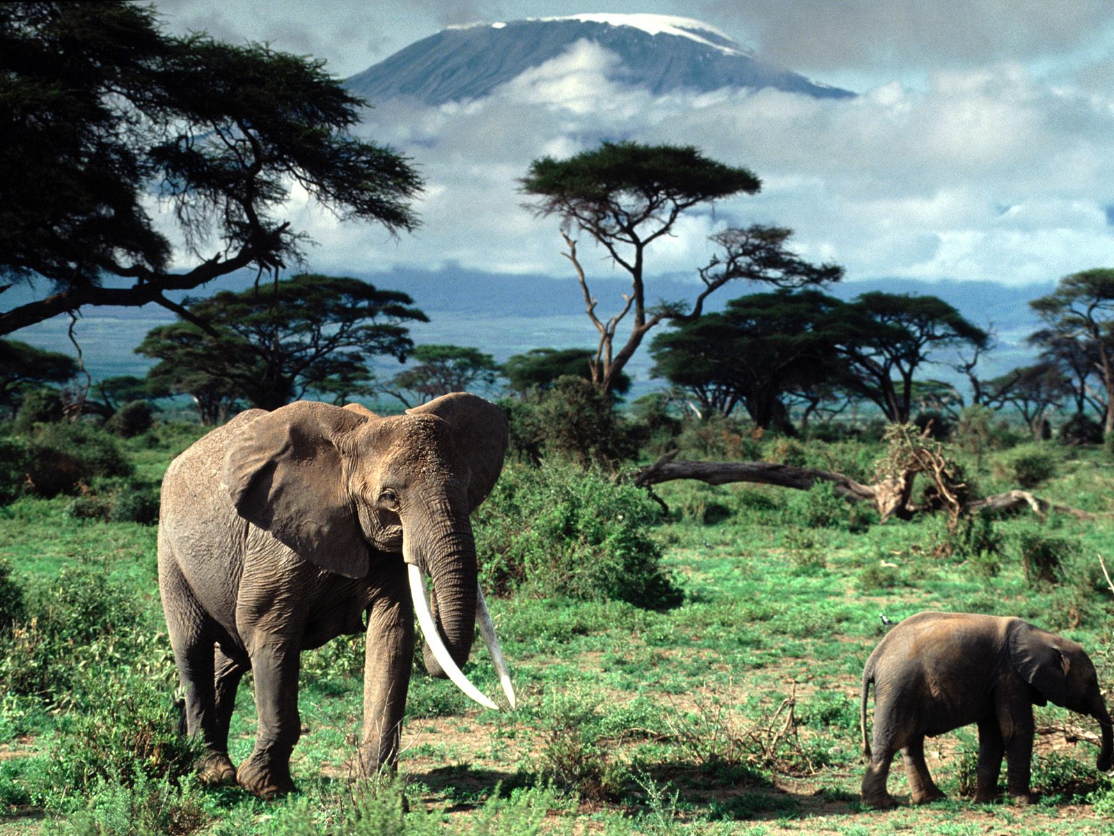
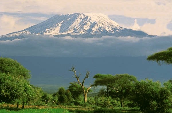
Mount Kilimanjaro rises majestically from a rolling plain close to the Indian Ocean from hot savanna to a barren and frigid 3-1/2 mile high peak. It’s the highest mountain in Africa and one of the largest free standing mountains in the world. Climbing Kilimanjaro is a must-do challenge for almost every trekker and mountaineer in the world.
Kilimanjaro National Park takes in the area above the 8,850 feet, or 2,700 meters, on the mountain. It includes the moorland and highland zones, Shira Plateau, Kibo and Mawenzi peaks. In addition, the Park has six corridors or rights of way through the Kilimanjaro Forest Reserve. The Forest Reserve, which is also a Game Reserve, was established in 1921; the Park was established in 1973 and officially opened in 1977.

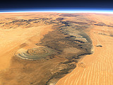
Kilimanjaro is a giant stratovolcano reaching an elevation of 19,335.6 ft. (5,895 m). Other names for this volcano are: Kilima Dscharo, Oldoinyo Oibor (white mountain in Masai), and Kilima Njaro meaning shining mountain in Swahili. This volcano’s highest and youngest cone is named Kibo. Shira to the west and Mawenzi in the east are older cones that make up Kilimanjaro. Kibo has not been active in modern times, but steam and sulfur are still emitted. At the top of Kibo’s summit is a 1 1/2 mile (2 1/4 Km) wide crater.
Kilimanjaro is the largest of an E-W belt of about 20 volcanoes near the southern end of the East African Rift Valley. Also prominent in this belt are Ngorongoro caldera – a superb wildlife refuge, Ol Donyo Lengi – a carbonitite volcano, and Meru. Kilimanjaro is a triple volcano with the youngest and central peak of Kibo being 7.5-8.7 miles (12-14 km) from Shira to the west and Mawenza to the east. As all of Kilimanjaro’s climbers know the gentle lower slopes steepen to 30 degrees about 13,000 ft.(4 km) elevation.
Shira is topped by a broad plateau, perhaps a filled caldera, and erosion has cut deeply into a remnant rim. In contrast, Mawenzi’s summit is a steep rocky peak surrounded by cliffs 1,600 ft.(0.5 km) to 4,900 ft.(1.5 km) high. Erosion has removed the original crater, and a great horseshoe shaped ridge opens to the northeast. Mile-deep gullies with 30-45 degree gradients make many places practically inaccessible. Massive series of radial and concentric dyke swarm make up more than 30-40 percent of the summit area of Mawenzi. Kibo’s glacier-clad summit, the highest spot in Africa, is a 1.2 x 1.7 mile (1.9 x 2.7 km) caldera, with an inner crater nearly a mile (1.3 km) wide, and inside that a deep, 1,148 ft. (350 m) wide central pit. Original volcanic forms are preserved at the summit and on many of the flanks, except on the south side where glaciers have cut deeply into the cone. Nearly 250 satellitic cones occur on Kilimanjaro, most following SE and NW trends. Estimates suggest that of a total volume of about 1,150 cu. miles, Mawenzi and Shira each contribute roughly 120 cu. mi. of andesites and basalts, Kibo has the same volume of similar but unexposed rocks, plus an additional 107 cu. miles. Interestingly, more than half of Kilimanjaro’s volume is represented by older, basal basalts (672 cu. mi.), so once again- as in Cascade stratovolcanoes – a basaltic shield is the most important, but least conspicuous element of a chemically complex volcano. Kilimanjaro- Africa’s largest volcano and among the largest on the Earth is indeed a beautiful and fascinating volcano of the world.

Even though you can climb throughout the year, January, February and September are the best months, with July, August, November and December also being good.
Equatorial to arctic conditions are present on Kilimanjaro. The range begins with the warm, dry plains with average temperatures of 85°F, ascends through a wide belt of wet tropical forest, through zones with generally decreasing temperatures and rainfall, to the summit where there is permanent ice and below freezing temperatures.
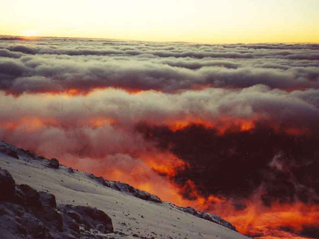
The rainiest period is March to June. The fact that most months of the year have so few rainy days makes it possible to climb in relatively good conditions year round. During the rainy period of March to May, clouds tend to pile up and over the summit, dropping snow on top and rain at the base. Visibility can be limited by cloud cover even when no rain falls. The temperature at this time of year is relatively warm. The dry season, beginning in late June and through July can be very cold at night, but usually is clear of clouds. August and September are also cool and can have completely clear days, but usually a dripping cloud belt girdles the mountain above the forest and moorland. The summit can be totally clear and the successful climber looks down on a vast sea of clouds with distant mountain peaks poking through like islands.
The shorter rainy period of October to December often has thunderstorms that pass over the mountain, dropping rain as they go. Typically the clouds disappear in the evening, leaving nights and mornings clear with excellent visibility. January and February are usually dry, warm and clear with brief rain showers which make for good climbing conditions.
Kilimanjaro towers above the Great Rift Valley, possible birthplace of humankind and the site of the Leakey’s research in the Olduvai Gorge. This gives Kilimanjaro an awesome mystique. One can imagine the mountain towering above our ancestors, making an early, continual impression on the species. When you walk the mountain, you’ll probably encounter some odd, purposeful arrangements of stone. Your guides will claim to not know what they mean. Perhaps they don’t.

…on Kilimanjaro, some mysteries may never be answered…
source 1 2

Tunisia

Tunisia’s beautiful beaches and historical treasures attract millions of tourists from all over the world.

Nearly 5 million tourists visited Tunisia in 1999.In 2004 they reached more than 6 million.

American and most European tourists do not require visas to enter Tunisia. There are more than 722 hotels in the country, totaling 191.955 beds. Seven international airports, and eight passenger ports connect Tunisia to the United States and Europe. The capital city, Tunis, is a two-hour flight from Paris and London and a fifty- minute flight from Rome. Daily flights connect Tunisia to virtually all European, African and Middle Eastern destinations.

MEDITERRANEAN COAST

Visitors sunbathe, dive, sail, and fish along the vast stretches of glistening, white sandy Mediterranean beaches covering a 810- mile coast. Beach resorts include Tabarka, Hammamet, Sousse and Jerba.

El-Kantaoui’s 27-hole golf course and Andalusian style marina is a fully-integrated tourism complex.Tunisia’s Saharan tourism attractions includes an international golf course situated under Tozeur’s lush palm groves as well as many desert festivals.

The perched village of Sidi Bou Said offers a unique scenery of domes, arched doors and balconies in blue and white set against a sparkling sea.

ARCHAEOLOGY

Punic and Roman archaeological sites can be visited in Carthage and other historical areas around the country. They include second century Roman temple in Dougga, the Phoenician port of Utica, Sbeitla’s Roman temples and arches, Bulla Regia’s Roman villas and El Jem’s Coliseum, which is second only to Rome. The Bardo Museum, near Tunis, boasts the largest collection of Roman mosaics in the world.

ARCHITECTURE

Masterpieces of Arab-Islamic architecture attract the attention of visitors. Among them: the Great Mosque of Kairouan, the Moslem World’s fourth holiest city, and the Great Mosque of Ezzitouna, at the center of the old city (the Medina) of Tunis.

CULTURE

Tunisia, a melting-pot of different civilizations, has always had a rich cultural activity, as testified by its prestigious museums and cultural institutions and by the various international festivals held throughout the year. Sustained efforts have been deployed to promote the cultural sector. The Heritage Code grants companies important tax breaks to encourage investments in restoration and protection of archaeological monuments (e.g. Cathedral of Carthage;) promulgation of legal texts allows free importation of books and paper destined for cultural purposes and the exemption from customs duties of musical instruments.

A whole strategy has been put in place to set up institutions serving as points of reference in the various domains of cultural activity. Among them, the National Dance Center of Borj El Baccouche, the House of Baron d’Erlanger converted into a Center for Arab and Mediterranean Music, and the Husseinite Museum (covering the period of the Beys) in the Palace of Ksar Said.

Other projects are in the process of completion, such as the Museum of Modern Art, located at the Palace of El Abdellia, and the National Cultural Center of Tunis. In addition, the International Cultural Center of Hammamet has been refurbished and transformed into the House of the Mediterranean, specializing mainly in theatrical arts. The institution of “Beit el Hikma” was converted into an Academy of Sciences, Arts and Letters in order to better contribute to the cultural and intellectual activity of Tunisia. The academy also welcomes distinguished scholars wishing to conduct research in various fields and serves as a meeting place for debates and exchanges between researchers, scholars and artists.

FESTIVALS

Tunisia hosts numerous international film, arts, and historical festivals, including the Summer festivals of Carthage, Dougga, and Hammamet, which host top international artists, the International Festival of El Jem for classical music, the Andalusian Music Festival of Testour, the Sahara Festival in Douz, the International Film Festival of Carthage, the Mythological Films Festival in Jerba and the Theater Festival of Carthage.