Ningwu Ice Cave, China

This is a sight that will really send a shiver down your spine. Not because it’s scary – but because of its sheer beauty. The caves are so cold it sends a shiver down the spine of people standing outside.
The caves are, like many interesting corners of China, not yet on any tourist trail, but are spectacular to visit. Situated in the middle of the Yellow River valley, in the heart of one of China’s most scenic regions, these incredible ice caves are more than three million years old. Identified by the Chinese Academy of Sciences Institute of Geology, cave expert on-site inspection: this hole is formed in the Cenozoic Quaternary Ice Age, hence the name of years the ice cave.
The experts said that only the first of nine ice cave in the ice cave ranked the country more than 10,000 caves. Divided into upper and lower five-story drill ice cave, under the ice stairs, over ice stack, available layers sightseeing. Each floor can accommodate dozens of people. Over 20 meters in diameter, the hole at its widest point, the narrowest of over 10 meters. Formed by the ice, icicles, ice curtain, frozen waterfalls, ice, ice Buddha, ice sheets, ice bell, Iceman, ice Buddha, etc., strange, to name a few. Carved inside the cave, large and small views or exquisite, dazzling crystal, or graceful, magnificent, all amazing.
Photos shows an ancient ice cave in Ningwu County of Xinzhou City, north China’s Shanxi Province, 50 km west of the Wa township Ma Tei Village Office next to the travel lanes, 2300 meters above sea level. The cave, lit up by coloured lights, is more than 100 meters long. Inside it is covered with thick ice that freezes in the winter and remains all year.
Huge icicles are formed which hang from the ceiling, in sharp contrast with the green summer foliage outside.
They’re so chilly that even standing outside you can feel the cold – even on a hot summer’s day.

http://pagead2.googlesyndication.com/pagead/show_ads.js

Danxia , China


Bordering on Hunan Province to the further north and Jiangxi Province to the east, Shaoguan is a hub of communications connecting Central China with South China. It lies in the north of Guangdong Province, thus having been called the northern Gate of Guangdong. Covering an area of 18,579 square kilometers (7,173 square miles), Shaoguan has a population of 3,148,500 (2003) and consists of three urban districts, six counties and two cities. With a long history, an important geographic location, aged cultural tradition and rich natural resources, Shaoguan is an excellent tourist city in China, a national advanced clean city and a civilized city in Guangdong as well.

History
Shaoguan is one of the earliest birthplaces of Lingnan’s ancient culture, the native place of Maba People and the rising place of Shixia’s culture. As early as 100 thousand years ago, the ancestors of North Guangdong labored and lived here. Shaoguan was called Shaozhou in Sui Dynasty (581 – 618) and set up the customhouse in Ming Dynasty (1368 – 1644) and Qing Dynasty (1644 – 1911) and thus began to be called the present name.

Landform
At Shaoguan, the Wu River from the northwest and the Zhen River from the northeast join up to create the Beijiang River which flows south to Guangzhou. Shaoguan’s downtown area lies on a peninsula shaped by the Zhen River and the Wu River. There are seven bridges crossing the three rivers. Located in a comparatively high mountainous region, Shaoguan City is popular for its beautiful natural scenery with a few hot springs.

Climate
Shaoguan is in the middle subtropical monsoon area of humid type. The four seasons are very distinct with a lot rain in summer and occasionally snowfall in winter. The annual rainfall is 1,910 millimeters (6.3 feet) and the average annual temperature is 20.7 degrees Celsius (69.3 degrees Fahrenheit). The rainy season and hot season are basically of the same time, favorable to plant growth and agricultural production.

Tourist Resources
Shaoguan has peculiar landscapes and rich tourist resources. It has 11 scenic spots, conservation areas, forest parks, key temples and cultural relics at national level and 19 scenic spots, temples and cultural relics at provincial level, such as Fengcailou Mansion, Mausoleum of Zhang Jiuling, Mt. Furongshan and Maozifeng Peak. The most well known natural view is Danxia Mountain, one of the four famous mountains of Guangdong Province, distinctive for its steep stone walls, peaks and pillars. Besides, there is a modern communication network of railways, highways and waterways organically connected. Shaoguan has become a modern city with convenient transport facilities and it was rated as China’s Excellent Tourist City in 2001.

– Mount Danxia

Located in the northeast of Shaoguan city in Guangdong Province, Mount Danxia is called ‘Red Stone Park of China’, 45 kilometers (28 miles) away from downtown Shaoguan. Danxia means the ‘red rays of the sun’ in Chinese words. It is the peculiar landform characterized by red steep cliffs, flat valleys and sheer body. Geologist classifies the same sort of such formations into ‘Danxia Landform’. Mount Danxia is the most beautiful and typical among the other 700 landforms which are to be found elsewhere in China.

The recognition of Mount Danxia can be traced back to 1,500 years ago, when our ancestors approached it and put their admiration into beautiful poems. The numberless sized red stone peaks, stone walls, stone bridges and the like are scattered randomly over the mountain.

What impress us most are the peaks. The top is flat, one or more sides are almost upright cliffs, while the opposite side is the gently sloping hill. More often the gentle places are covered by lush vegetation, and the place that the red stones expose are usually the craggy cliffs. The unique body endows the peaks with the beauty of majesty as well as the charm of softness. Standing in front of the cliffs, the stone wall of hundreds of meters high is like the magnificent pillar that holds up the sky. Overlooking the mountain from afar, the line of the summit and mountain slopes brings you a feeling of softness and intimacy.

The peculiar red stone in Mount Danxia came into being 100 million years ago. It was an inland basin here at that time in which the surrounding rocks broke and accumulated. It was pretty hot and dry then, thus the rock was oxidized and turned rusty. Undergoing a period of 30,000,000 years, the deposits in the basin gradually transformed into red sandstone and conglomerate. Later, as a result of the crustal movement, the land rose and turned into the mountainous area. The long-time erosion made it present Danxia Landform constituted by red sandstone.

Mount Danxia is not only bright in color, but peculiar in outlook. Yangyuan Stone, Yinyuan Stone and Longlin Stone are the most distinctive among the others. Yangyuan Stone is a colossal stone rising sharply into the sky with the height of 28 meters (92 feet) and the diameter of 7 meters(7.7 yards). Yinyuan Stone is a crack that was eroded by the running water on the mountain, and it is considered as the ‘Mother Stone’ and ‘Source of Life’. The two special stones face each other across the mountain, one is masculine and the other is feminine, one is firm and the other is tender. The perfect match of the two stones is far enough to stir up your astonishment and exclamation. The surface of Longlin Stone has some similarity to the scale of the dragon, connected to be the lines by thousands of honeycomb-like holes. The color of the epiphytic moss varies as the climate changes, resembling a huge dragon on the stone wall, undoubtedly a wonder in nature.

http://pagead2.googlesyndication.com/pagead/show_ads.js

Mysterious Toyama Bay

For the past 10,000 years, the sea forest has stood just as it is today. This mysterious world is a large bay on the east side of the Noto Peninsula, which projects into the Sea of Japan in west-central Japan. 3,000-meter-high mountains suddenly drop to 1,000 meters below the surface of the ocean creating wondrous natural phenomena and extreme habitat for exotic sea creatures. Known for its wide variety of fish, Toyama Bay has been dubbed “a natural fish tank,” because throughout the year many kinds of fish (meaning “very fresh” in Toyama’s local dialect) are caught and then unloaded from ships at bustling fishing ports along the coast of the bay, such as Uozu, Shinminato, and Himi. Nutrient-rich springs overflow from deep beneath the sea-bed, causing several hundred species of sea life to inhabit the area.

The coastal shelf in Toyama Bay is small, and the sea floor drops sharply a short distance from the land, with the deepest parts of the bay being more than 1,200 meters deep. Into the surface seawater of the bay, warm-water fish species are carried by the warm Tsushima current, while in the deep seawater at a depth of over 300 meters coldwater fish species live in the much cooler waters of the Japan Sea (deep seawater) at a temperature of around two degrees Celsius. Thus, Toyama Bay has an environment where both warm- and cold-water marine life can exist, and thus it is a treasure trove of marine resources.
Seventy percent of the total fish catch is comprised of migratory warm-water fish such as tuna and yellowtail, while the rest includes many kinds of deep-water fish and shellfish such as sweet shrimp, benizuwai crab, Japanese ivory shell, firefly squid, and white shrimp. Rare firefly squid and white shrimp are particularly valuable marine resources that are rarely found in areas other than Toyama Bay. Every spring, a large number of the tiny squids come to the coast from waters more than 200 meters deep for spawning. The mysterious pale blue light emitted by the squids in the night sea when they are caught is a common spring sight in Toyama Bay.
Watasenia scintillans, or the Firefly Squid, is only 3 inches long, but packs a stunning feature in that small package. At the end of their tentacles are special organs called photophores that light up like glow sticks at a rave. In the Toyama Bay, in the central Japan Sea, the squid are found in fantastic abundance. Normally living at 1200 feet underwater, a v shaped canyon in Toyama bay pushes the current, and the squid, to the surface in massive numbers where, forced up, the millions of squids turn the bay into a writhing, gleaming blue froth.
Fished by the ton from March to June, when the fishing boats dump the nets onto the boat floor the squirming squids light up and turn the boats themselves into blue beacons. Thankfully, for the curious visitors, one need not sign up to work on a Japanese fishing-boat tour to see the phenomenon.
The habitat of the world-famous glowing firefly squid limits itself to the Western Pacific ocean. The firefly squid is a middle-deep sea squid that can live on depths of 600 to 1200 (365m) feet. The body of these little squids are covered with photophores that give a blue light. The main goal of these photophores is to lure little fishes, so that it can catch them easier. Just as the vampire squid, the firefly squid has its photophores totally under control. He can make different light show patterns with these photophores to communicate with others, to distract a predator or even lure their pray.
The reproduction of the firefly squid, once a year (March to June) millions of squids come together to fertilize and to drop their eggs in the Toyama Bay in Japan. The big reunion of these squids is one big light show that you can admire and it attracts thousands of tourists. Once the firefly squids have done their job, they die. The firefly squid has a one year life-cycle and once that year is over they die and wash up on the shore. This event is very important for other sea creatures and sea birds who enjoy eating the dead bodies of the firefly squid.
Firefly squids are just as many other sea creature a delicacy in Japan and they’re mainly caught when the firefly squids come together to mate.
Sightseeing
Early in the morning, after 3 AM, sightseeing boats depart the Namerikawa fishing port (Namerikawa is also home to the world’s only museum dedicated to the firefly squid) in Toyama prefecture, making a short journey to fixed nets located about 1 to 2 km offshore. As the fishermen haul in their nets, the light emitted by the firefly squid causes the sea surface to glow a cobalt blue, evoking squeals of delight from the tourists.
Toyama Bay’s firefly squid fishing season opened on March 1 and is expected to continue until the end of June. Sightseeing boats are scheduled to run until May 7.


http://pagead2.googlesyndication.com/pagead/show_ads.js

Flying Tennis! The World’s Highest Tennis Court at Burj Al Arab, Dubai

The world’s highest tennis court stands atop the one of the highest hotel in the world – Burj al-Arab at Dubai. On February 22, 2005, the Burj al Arab hosted Andre Agassi and Roger Federer to play a match on their helipad tennis court before heading to the US$1 million Dubai Duty Free Men’s Open, which was the first round of the two-week Dubai Tennis Championships. The tennis legends couldn’t resist the temptation to have a friendly ‘hit’ on the world’s most unique tennis court. The court is circular in shape ,and also doubles as a helipad, hovering 211 meters above the Arabian gulf and covers a surface area of 415 sq m.

Would you like to play round of tennis at this height?
Here is some info about hotel so you can book your game today!

Designed by Tom Wright and completed in 1999, the hotel features a double membrane PTFE fiberglass covering that reduces solar heat gain, but lets in filtered light. Burj Al Arab is located on Dubai’s Jumeirah Beach strip, 15 km from the main city centre and 25 km from Dubai International Airport. It is Dubai’s most recognisable landmark and the fourth tallest hotel in the world at 321 m (1,053 ft) and stands 280 metres offshore on a man-made island, linked to the mainland by a slender, gently curving causeway. Resembling the sail of a ship, the iconic hotel gives itself a 7 star rating, although we’re not really sure if you can go above 5 on the luxury scale. It is well served by taxis and has its own fleet of chauffeur driven Rolls-Royces, BMWs, and a helicopter.

Contact Details:

Burj Al Arab
PO Box 74147, Dubai, UAE

Tel: +971 4 3017777
Fax: +971 4 3017000

http://pagead2.googlesyndication.com/pagead/show_ads.js

Dubai Duty Free Tennis Championships

Pretty much anybody who is anybody in tennis will be in Dubai over the next couple of weeks in one of the biggest of the non-Grand Slam tournaments. The $2 million Dubai Duty Free Tennis Championships is certainly a big deal.

Eight of the top ten ranked men will be in the city, which has already become a serious sporting destination, while seven of the top ten women will also be there. Interestingly, the women play in week one, starting on Monday, and then the men are in action in week two.

Since its inaugural tournament in 1993, the Dubai Duty Free Tennis Championships has consistently showcased the world’s best players in competition and also in spectacular locations around Dubai.
The Dubai Tennis Championships (also known as the Dubai Duty Free Tennis Championships for sponsorship reasons) (formerly known for sponsorship reasons as the Barclays Dubai Tennis Championships and the Dubai Duty Free Men’s and Women’s Championships) is a professional tennis tournament owned and organized by Dubai Duty Free and held annually in Dubai, United Arab Emirates on outdoor hardcourts. The tournament organizes both a men’s and women’s event. The tournament takes place under the patronage of H.H. Sheikh Mohammed bin Rashid Al Maktoum, Vice-President and Prime Minister of the UAE and Ruler of Dubai.

In 2005, two ATP World Tour Champions – Andre Agassi and Roger Federer – scaled the Burj Al Arab for a friendly practice session atop the helipad at the iconic hotel.

 — click here for more info —

The respective winners of the recent Australian Open are ready to follow their success down under with a good showing in the Middle East.
For the women, Justine Henin and Venus Williams have enjoyed themselves over the years, with four and two wins each respectively, but last year the crown went to Caroline Wozniacki.
The Dane was knocked off the number one spot just last month after her quest for a first Grand Slam win ended in failure in Melbourne. Now the number four in the world, she has her sights set on the winner of the Australian Open and the new number one, Victoria Azarenka of Belarus.
Wozniacki will have to do better than last week, when she was knocked out of the Qatar Open early by Lucie Safarova, despite having three match-points.
“I just want to get out of here. You don’t want to stay when you lose a match like that,” Wozniacki said, and added, “It’s really disappointing but you have to move on.”
Azarenka returns to the Middle East in much better shape than she was a year ago when defeats in Doha and Dubai almost prompted her to quit the sport.
“My mum told me to come home and rest, and not be crazy about it,” she said. “And my gran pointed out there are things so much harder in life than tennis matches.”
“Last year I was in a bit of a mess. I couldn’t control any of my emotions. I had to change my mentality. So now I don’t try to, you know, think ‘why is this happening to me?’ Instead I just try to accept and deal with it.”
Novak Djokovic has dominated men’s tennis in the past few years and Dubai has been no exception with the last three titles going the Serbian’s way.
Already, 2012 couldn’t have gone better. He won the Australian Open and last week was given his country’s highest honor, Order of the Karadjordje’s Star of the 1st degree by Serbian president Boris Tadic.
He’s going to take some stopping soon…

 ATP (Men’s)

  • Name: Dubai Duty Free Tennis Championships
  • Category: ATP World Tour 500
  • Place: Dubai, U.A.E
  • Date: 27.02.2012-03.03.2012
  • Draw Size: S-32 D-16
  • Surface: Hard
  • Prize Money: $ 1,700,475
  • Total Financial Commitment: $ 2,313,975
  • Ticket Hotline: +9714-224-4568

WTA (Women’s)

  • Prize Money: $2,000,000
  • Surface: Hard/Outdoors 
  • Tournament Director: Salah Tahlak

Dubai Tennis Stadium:

The Aviation Club is home of The Dubai Tennis Stadium which was inaugurated in 1994 and has hosted the Dubai Tennis Championships ever since. The state-of-the art stadium is home to the prestigious centre court that has hosted tennis stars Roger Federer, Andre Agassi, Goran Ivanisevic, Venus & Serena Williams, Lindsay Davenport and many more.
The Dubai Tennis Stadium was voted “Best Venue” by players on the ATP Tennis Tour for three consecutive years.


Tournament Schedule :

Day Date WTA Rounds
Sat 18-Feb Qualifying Women’s
Sun 19-Feb Qualifying Women’s
Mon 20-Feb 1st Round
Tue 21-Feb 2nd Round
Wed 22-Feb 3rd Round
Thur 23-Feb Quarterfinals
Fri 24-Feb Semifinals
Sat 25-Feb Finals

Day Date ATP World Tour Rounds

Sat 25-Feb Qualifying Men’s
Sun 26-Feb Qualifying Men’s
Mon 27-Feb 1st Round
Tue 28-Feb 2nd Round
Wed 29-Feb 3rd Round
Thur 01-Mar Quarterfinals
Fri 02-Mar Semifinals
Sat 03-Mar Finals

MEN
SINGLES DOUBLES
1993 Karel Novacek Anders Jarryd/John Fitzgerald
1994 Magnus Gustafsson Mark Woodforde/Todd Woodbridge
1995 Wayne Ferreira Grant Connell/Patrick Galbraith
1996 Goran Ivanisevic Byron Black/Grant Connell
1997 Thomas Muster Goran Ivanisevic/Alexander Groen
1998 Alex Corretja Mahesh Bhupathi/Leander Paes
1999 Jerome Golmard Wayne Black/Sandon Stolle
2000 Nicolas Kiefer Jiri Novak/David Rikl
2001 Juan Carlos Ferrero Joshua Eagle/Standon Stolle
2002 Fabrice Santoro Mark Knowles/Daniel Nestor
2003 Roger Federer Leander Paes /David Rikl
2004 Roger Federer Mahesh Bhupathi/Fabrice Santoro
2005 Roger Federer Martin Damm/Radek Stepanek
2006 Rafael Nadal Paul Hanley/Kevin Ullyett
2007 Roger Federer Fabrice Santoro/Nenad Zimonjic
2008 Andy Roddick Mahesh Bhupathi/Mark Knowles
2009 Novak Djokovic Rick de Voest/Dmitry Tursunov
2010 Novak Djokovic Simon Aspelin/Paul Hanley
2011 Novak Djokovic Sergiy Stakhovsky/Mikhail Youzhny
WOMEN
2001 Martina Hingis Barbara Rittner/ Marlene Weigartner
2002 Amelie Mauresmo Barbara Rittner/Maria Vento Kabchi
2003 Justine Henin-Hardenne Svetlana Kuznetsova/Martina Navratilova
2004 Justine Henin-Hardenne Janet Husarova/Conchita Martinez
2005 Lindsay Davenport Virginia Ruano Pascual/Paola Suarez
2006 Justine Henin-Hardenne Kveta Peschke/Francesca Schiavone
2007 Justine Henin Cara Black/Liezel Huber
2008 Elena Dementieva Cara Black/Liezel Huber
2009 Venus Williams Cara Black/Liezel Huber
2010 Venus Williams Maria Jose Martinez Sanchez/Nuria Llagostera Vives
2011 Caroline Wozniacki Liezel Huber/Maria Jose Martinez Sanchez

Grandstand Ticket Prices

Women’s Week
CATEGORY
DAY
TIMINGS
2012
Day 1 (Feb 20)
Mon
2:00 AND 7:00 PM
50
Day 2 (Feb 21)
Tues
2:00 AND 7:00 PM
50
Day 3 (Feb 22)
Wed
2:00 AND 7:00 PM
50
Day 4 (Feb 23)
Thurs
2:00 AND 7:00 PM
150
Day 5 (Feb 24)
Fri
2:00 AND 7:00 PM
250
FINALS (Feb 25)
Sat
5:00 AND 7:00 PM
350
Total Price Per Week
900

Men’s Week
CATEGORY
DAY
TIMINGS
2012
Day 1 (Feb 27)
Mon
2:00 AND 7:00 PM
50
Day 2 (Feb 28)
Tues
2:00 AND 7:00 PM
50
Day 3 (Feb 29) – SOLD OUT
Wed
2:00 AND 7:00 PM
50
Day 4 (Mar 1) – SOLD OUT
Thurs
2:00 AND 7:00 PM
150
Day 5 (Mar 2) – SOLD OUT
Fri
2:00 AND 7:00 PM
250
FINALS (Mar 3) – SOLD OUT
Sat
5:00 AND 7:00 PM
350
Total Price Per Week
900


International Ice and Snow Festival in Harbin

The 28th Harbin International Ice and Snow Festival will start on December 1, 2011 and last to February 29, 2012. The ceremony will be officially launched on January 5, 2012. As it before the festival is held with many winter activities, such as alpine skiing, sledding, winter-swimming, ice sculpture competition, ice & snow carnival, ice lantern exhibition and firework display etc.
The annual Harbin International Ice and Snow Festival has been held since 1963, interrupted for a number of years during the Cultural Revolution until it was resumed in 1985. Harbin is the capital of Heilongjiang province, in northeastern China. It is nicknamed “Ice City” and aptly so for winter January temperatures that average minus 18 degrees Celsius, under the influence of the cold winter wind from Siberia.
In these stunning photographs the festival’s amazing sculptures are seen illuminated from the inside after night has fallen – with visitors meandering in between the impressive works.

Those who attend the event can navigate the ice cities on foot or via the festival’s horse and carriage rides. As well as walking around and marvelling in awe at the colourful creations, they can also zip down snowy slides or climb up the staircases of ice castles and investigate what’s inside.
The Harbin Ice and Snow Festival is one of the world’s top ice festivals.

The best collections of ice artworks are exhibited in the following five main places:
  • Harbin Ice and Snow World – came into being in 1999 and is one of the world’s largest ice architecture parks. The inspiration for the ice and snow sculptures there usually is derived from traditional Chinese fairy tales or world famous architectures such as the Great Wall, the Egyptian Pyramids, etc.
  • Ice Lantern Garden Party – ice lantern in broad sense refers to a series of plastic arts using ice and snow as raw material combining ice artworks with colored lights and splendid music. The specific patterns of ice lantern include ice and snow sculptures, ice flowers, ice architectures and so on.
    Sun Island Scenic Area – is the site of the Snow Sculpture Exposition displaying a wonderful snow world. It has the world’s largest indoor ice and snow art museum and it opens to the public from November every year.
  • Zhaolin Park – is a ‘must see’ during the Harbin Ice Festival because it has a traditional program that shows the most excellent ice lanterns. With water, lights and the natural ice from the Songhua River running through Harbin as the material, the ice lanterns are made by freezing water, piling up ice or snow, then carving, enchasing, decorating, etc.
  • Yabuli International Ski Resort
Recommended Tours for Harbin Ice and Snow Festival Harbin:


http://pagead2.googlesyndication.com/pagead/show_ads.js

Kirkuk (Karkuk) – Iraq


Kirkuk is the largest Azeri city in Iraq. The Turkic population speaks the Southern dialect of the Azeri language, and besides Kirkuk this Turkic population is to be found in the Erbil, Mosul/Ninawa and Deyalah provinces. In tows and villages southeast from Kirkuk, large numbers of Azeris live as far as Al Miqdadiyah, Khanqin, and Mandali. Azeri speakers in Iraq are usually mentioned as Turkman, Turkmen or Turkoman, they use the Arabic script and many have Arabic or Kurdish as a second language.

The first Turkman were brought to Iraq by the Ommiad ruler Ubeydullah bin Ziyad in 54 Hegira. The invasion of Iraq by the Seljuk ruler Tugrul Bey in 1055 marked the beginning of Turkish control that lasted till 1918. The 11th and 12th centuries saw the strongest flux of Turkman settlers to Mesopotamia. Wars and the resulting treaties in the area eventually separated the Azeris in Iraq and Azerbaijan. Their languages, sharing the same root – the Oghuz group of Turkic languages – however, stayed basically the same. Furthermore, several important Azeri revered intellectuals – classical poets and scientists – are buried in Iraq. Several towns and villages found around Kirkuk bear the sames names as towns in Azerbaijan, such as Aghdash, Aghdam, Bilava, Aghsu, Guruchay, Boyat, Garabagh, Garagoyunlu, Amirli, Yayji, Yandija, Mardinli, Uchtapa, Khasa , Khasadaghli Chardakhli.

Calling the Azeri speakers “Turkman” dates from the Seljuk period. Currently the Turkman are represented by the ‘Turkman Front’, established in 1995 joining several Turkman political and social organizations. The Turkman community’s two main parties are divided in their support. One works in co-operation with the Kurdish authorities, the other is backed by Turkey and opposes a Kurdish state in northern Iraq – especially one that would adopt Kirkuk as its capital.

Turkey has tried to exert a strong influence on the Turkman, and often written Turkish is used by the Turkman, as opposed to the traditional Southern-Azeri dialect which predominates in the spoken form. In spite of this, from the Arab point of view, the language of the Iraqi Turkman is regularly mentioned simply as Turkish. The number of Turkman is estimated a 2.0-2.5 million – the third largest ethnic group in Iraq after the Arabs and Kurds. Historically, the Turkman formed a cultural buffer zone between the Arabs in the South and the Kurds in the north.

Under the Iraqi constitution of 1925 both Turkman and Kurds had the right to use their own languages in schools, government offices and press. By 1972 the Iraqi government prohibited the both the study of the Turkman language and the Turkman media and in 1973 any reference to the Turkman was omitted from the provisional constitution. During the 1980’s the regime of the Baath party prohibited even the public use of the Turkman language and the constitution of 1990 only states the the “people of Iraq consists of Arabs and Kurds”.
In 2003 the collapse of Saddam Hussein’s Baathist government brought new possibilities to the Turkman community that will have to be materialized in a difficult context, balancing the interests of Turkey and of the global super-power.

Kirkuk is located in northern Iraq, about 250 km north of the capital Baghdad near the foot of the Zagors Montains. Railway lines provide good connections with Baghdad and Arbil. Kirkuk has a population of over 600.000 and is the capital of the Al-Tamin governorate (muhafazah). Until 1974 the city was the capital of the Kirkuk governorate, which was reduced to a quarter of its original size by the Baghdad government, as a way of controlling the influence of the Azeri speaking population. The Iraqi government has also been very active in settling Arabs in the area as a way of inverting the ethnic balance. Turkman leaders say thousands of their community were forced into destitution in northern Iraq, while up to 20,000 made their way illegally to Europe throughout the 1990s. Currently Kirkuk still has a Turkman majority but the Kurdish and Arab communities are also important.

In post-Saddam Iraq, Kirkuk reveals some symptoms of becoming the centre of a struggle between the Turkmen and the Kurds, both of whom aspire to domination in the area.

The first commercial oil field in Iraq was developed in Kirkuk in 1927. Today Kirkuk is at the centre of one of the richest oil producing areas in the middle east, and pipelines connect it to the Mediterranean ports of Tripoli in Lebanon and Yumurtalik in Turkey. However the oil industry was affected first by the war with Iran and later by the American aggression and blockade. The area has also an textile industries and a strong agricultural sector, producing wheat, barley, fruits and sheep.

The city is built by the Hasa river on an area with archaeologic remains over 5000 years old, the city reached great prominence in the 10th and 11th centuries, under Assyrian rule when it was known as Arrapha. The oldest part of the town is clustered around a citadel built on an ancient tell, or mound. Saddam Hussein’s government had some unpleasant interventions in Kirkuk’s architecture, including the demolition of the Muhammediye Mosque, but the city is well worth visiting for the many ancient buildings and specially for the castle and citadel, and the 6th century Nabi Danial mosque located in the old quarter. Don’t miss the ethernal fire at Babagurgur.

Outside Kirkuk

Qalat Jarmo:
Located east of Kirkuk, Qalat Jarmo is an important prehistoric archeological site. The site became knwon for revealing traces of one of the world’s first village farming communities. The approximately dozen layers of architectural building and renovation yeild evidence of domesticated wheats and barley and of domesticated dogs and goats, suggesting the achievement of a settled agricultural way of life. Other artifacts found at Qalat Jarmo, such as flint sickle blades, milling stones, and – in the uppermost layers only – pottery, hint at the technological innovations made in response to the new way of food production. The original occupation of the site is estimated to have occurred at about 7000 BC.

Nuzu:
Modern Yorghan Tepe, Nuzu is an ancient Mesopotamian city, located southwest of Kirkuk. Excavations revealed revealed material extending from the prehistoric period to Roman, Parthian, and Sasanian periods. In Akkadian times (2334 BC to 2154 BC) the site was called Gasur; but early in the 2nd millennium BC the Hurrians, of northern Mesopotamia, occupied the city, changed its name to Nuzu, and during the 16th and 15th centuries BC built there a prosperous community and and important administrative centre.

Excavations in Nuzu uncovered excellent material for a study of Hurrian ceramics and glyptic art. An especially outstanding type of pottery, called Nuzu ware (or Mitranni ware) because of its original discovery there, was characterized by one primary shape – a tall, slender, small-footed goblet – and an intricate black and white painted decoration. In addition to these extraordinary ceramic artefacts, more than 4,000 cuneiform tablets were discovered at the site. Although written mostly in Akkadian, the majority of the personal names are Hurrian, and the Akkadian used often shows strong Hurrian influence. The Nuzu material also made possible an insight into specific Hurrian family law and societal institutions and clarified many difficult passages in the contemporary patriarchal narratives of the Book of Genesis.

Jerusalem, Israel


History
  • Early History to 1900

Despite incomplete archaeological work, it is evident that Jerusalem was occupied as far back as the 4th millenium B.C. In the late Bronze Age (2000–1550 B.C.), it was a Jebusite (Canaanite) stronghold. David captured it (c.1000 B.C.) from the Jebusites and walled the city. After Solomon built the Temple on Mt. Moriah in the 10th cent. B.C., Jerusalem became the spiritual and political capital of the Hebrews. In 586 B.C. it fell to the Babylonians, and the Temple was destroyed.

The city was restored to Hebrew rule later in the 6th cent. B.C. by Cyrus the Great, king of Persia. The Temple was rebuilt (538–515 B.C.; known as the Second Temple) by Zerubbabel, a governor of Jerusalem under the Persians. In the mid-5th cent. B.C., Ezra reinvigorated the Jewish community in Jerusalem. The city was the capital of the Maccabees in the 2d and 1st cent. B.C.

After Jerusalem had been taken for the Romans by Pompey, it became the capital of the Herod dynasty, which ruled under the aegis of Rome. The Roman emperor Titus ruined the city and destroyed the Temple (A.D. 70) in order to punish and discourage the Jews. After the revolt of Bar Kokba (A.D. 132–35), Hadrian rebuilt the city as a pagan shrine called Aelia Capitolina but forbade Jews to live on the site.

With the imperial toleration of Christianity (from 313), Jerusalem underwent a revival, greatly aided by St. Helena, who sponsored much building in the early 4th cent. Since that time Jerusalem has been a world pilgrimage spot. Muslims, who believe that the city was visited by Muhammad, treated Jerusalem favorably after they captured it in 637, making it the chief shrine after Mecca. From 688 to 691 the Dome of the Rock mosque was constructed.

In the 11th cent. the Fatimids began to hinder Christian pilgrims; their destruction of the Church of the Holy Sepulcher helped bring on the Crusades. Jerusalem was conquered by the Crusaders in 1099 and for most of the 12th cent. was the capital of the Latin Kingdom of Jerusalem. In 1187, Muslims under Saladin recaptured the city. Thereafter, under Mamluk and then Ottoman rule, Jerusalem was rebuilt and restored (especially by Sulayman I); but by the late 16th cent. it was declining as a commercial and religious center.

In the early 19th cent., Jerusalem began to revive. The flow of Christian pilgrims increased, and churches, hospices, and other institutions were built. Jewish immigration accelerated (especially from the time of the Egyptian occupation of Jerusalem by Muhammad Ali in 1832–41), and by 1900, Jews made up the largest community in the city and expanded settlement outside the Old City walls.

  • The Twentieth Century

In 1917, during World War I, Jerusalem was captured by British forces under Gen. Edmund Allenby. After the war it was made the capital of the British-held League of Nations Palestine mandate (1922–48). As the end of the mandate approached, Arabs and Jews both sought to hold sole possession of the city. Most Christians favored a free city open to all religions. This view prevailed in the United Nations, which, in partitioning Palestine into Arab and Jewish states, declared that Jerusalem and its environs (including Bethlehem) would be an internationally administered enclave in the projected Arab state. Even before the partition went into effect (May 14, 1948), fighting between Jews and Arabs broke out in the city. On May 28, the Jews in the Old City surrendered. The New City remained in Jewish hands. The Old City and all areas held by the Arab Legion (East Jerusalem) were annexed by Jordan in Apr., 1949. Israel responded by retaining the area it held. On Dec. 14, 1949, the New City of Jerusalem was made the capital of Israel.

In the Arab-Israeli War of 1967, Israeli forces took the Old City. The Israeli government then formally annexed the Old City and placed all of Jerusalem under a unified administration. Arab East Jerusalemites were offered regular Israeli citizenship but chose to maintain their status as Jordanians. Israel transferred many Arabs out of the Old City but promised access to the holy places to people of all religions. In July, 1980, Israel’s parliament approved a bill affirming Jerusalem as the nation’s capital. With suburbanization and housing developments in formerly Jordanian-held territory, Jerusalem has become Israel’s largest city. Strife between Arabs and Jews persists. The issue of the status of East Jerusalem, annexed by Israel but regarded by Palestinians as the eventual capital of their own state, remains difficult. In 1998, Israel announced a controversial plan to expand Jerusalem by annexing nearby towns.

Overview

Few cities inspire as much passion as Jerusalem (Yerushalayim in Hebrew, Al-Quds in Arabic), rooted deep in the past and revered by three major religions.

With its pleasant, temperate climate, fine upland setting, extraordinary historical sites and world-class museums, Jerusalem fascinatingly contrasts ancient and modern, oriental and western.

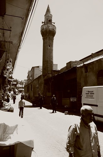
The larger part of the city, including the city center with its shopping and leisure district, is vibrant, Jewish West Jerusalem, characterized by broad avenues, busy pedestrianized streets and squares, cafes, restaurants and vivacious nightlife. Smaller East Jerusalem, predominantly Arab, is a 19th-century neighborhood lying north of the Old City. It has a slow but chaotic pace of life, with crowded, colorful street markets.

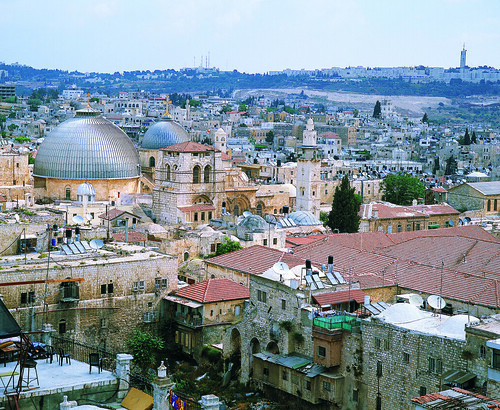
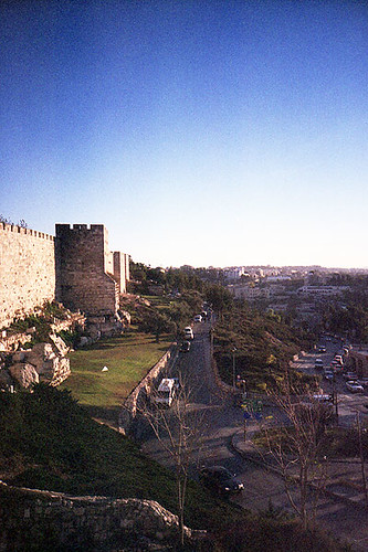
The Old City, on the eastern boundary, is where most of Jerusalem’s main sights are found. Enclosed within awesome 16th-century stone walls, are a labyrinth of winding lanes where visitors to the city spend much of their time.

The Old City is divided into quarters, named after its four major communities in the 19th century: Arab, Jewish, Christian and Armenian, and preserving those sharp distinctions to this day. Within minutes, you may wander from calm squares where Jewish children play under the watchful eye of their mothers, to the hustle and bustle of an Arab souk, and into a tranquil Armenian garden, before arriving at the splendor of a medieval citadel.

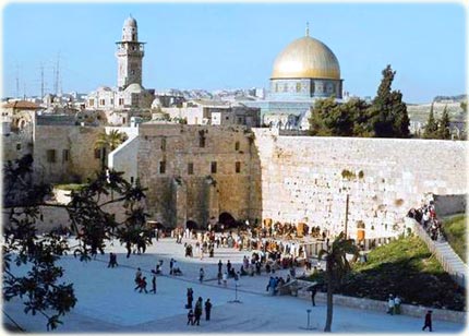
Jerusalem came into being over 3000 years ago as the site of the Jewish Temple. The Western (or Wailing) Wall at the foot of Temple Mount is all that survives of the Temple, destroyed by the Romans, yet it remains Judaism’s most revered place of prayer.

Extensive restoration and archaeological exploration gives astonishing insight into the structure and layout of the vast Temple in the time of Jesus.

For Orthodox and Catholic Christians, the Church of the Holy Sepulchre encloses the site of the Crucifixion and tomb where Jesus was laid, having carried the cross here along the Via Dolorosa.

The Muslim’s beautiful gilded Dome of the Rock on Temple Mount is Jerusalem’s most iconic landmark, while Al-Aqsa mosque, beside it, is proclaimed Islam’s third holiest shrine.

Israel declared Jerusalem its capital in 1950 but this is not internationally recognized. Most national institutions are in West Jerusalem, part of the state of Israel since the War of Independence following its creation in 1948. East Jerusalem and the Old City were first annexed by Jordan in 1948, then in 1967 by Israel, which integrated them into a reunited Jerusalem.

  • Sightseeing Overview

The compact size of Israel means that almost anywhere (with the exception of Eilat) is accessible for a day trip from Jerusalem. The coastal cities of Tel Aviv, Akko and Haifa, or the coastal ruins of ancient Caesarea, can easily be visited in a day, as can the area around the Sea of Galilee. There is enough to see in most of these places to merit a longer visit but, in terms of historical and religious sites, there is little to match Jerusalem.

The first stop for any visitor has to be the Old City, which contains the sacred sites that have caused such turmoil and unrest. It’s divided into quarters (the Armenian, Christian, Jewish and Muslim) each with its unique identity and character.

When sightseeing or just exploring, visitors should be aware of the intense campaign of terrorism being waged against Israel. Popular crowded venues, such as busy street markets, restaurants and cafes, crowded buses, discos, have especially been targeted by suicide bombers.

Security guards have now been posted at the doorways or entrances to most such locations and it is advisable to be wary of venues that have not put any security measures in place. To date, tourist sights have not been struck by the bombers, and Arab areas or Muslim sites are of course unlikely to be hit.

Tourist Information
Israeli Government Tourist Office (IGTO)
Tourist Information Center, Jaffa Gate, Old City.
Tel: (02) 628 0382.
Website: http://www.jerusalem.muni.il
Opening hours: Sun-Thurs 0830-1545, Fri 0830-1245.

Passes
A two-day pass for the 99 bus, which gives a guided tour of the city, will allow discounted entry to the Israel Museum, Tower of David Museum and the Biblical Zoo. It can be bought at ticket offices at these sites or from the bus drivers (see Bus Tours in Tours of the City).

Key Attractions:

Temple Mount

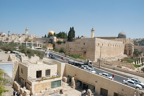
Temple Mount (Har Habayit in Hebrew, Al Haram ash-Sharif in Arabic), also called Mount Moriah, is sacred to both Islam and Judaism. It is a natural hill, which was built up artificially to support the huge Jewish Temple that stood here for a thousand years in Biblical times. Temple Mount has remained the focus of the Jewish religion ever since – when praying, Jews worldwide still face Temple Mount.

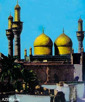
It was from a black rock within the complex, that, according to the Koran, Muhammad made his ascension to Heaven at the conclusion of his dreamt ‘Night Ride’ from Mecca, and, according to the Bible, it was here that Abraham offered Isaac for sacrifice. With the arrival of Islam in the seventh century, the octagonal, blue-tiled Dome of the Rock, with its huge gold dome, was built over the large black rock. Dominating the skyline of the Old City, its dome glinting in the sunshine, this beautiful building is Jerusalem’s most famous landmark and an absolute must for visitors.

Also on Temple Mount is the Al Aqsa Mosque, the oldest mosque in Israel and (unlike the Dome of the Rock) an actual place of Muslim worship. Its silver dome dates from the 11th century. The Islamic Museum, the third building within the complex, contains Islamic artifacts and relics. Only one of the 10 gates to the complex, Al-Mughradia (Moors) gate, allows entry for non-worshippers. This is located to the right of the Western Wall and is accessed from Western Wall Plaza.

Access from Western Wall Plaza (Old City)

Website: http://www.al-aqsa.com (Muslim site) or http://www.templemount.org (Jewish site)
Opening hours: Closed during all prayer times (variable); otherwise Sun-Thurs 0730-1030 and 1230-1330; Sun-Thurs 0730-1030 (during Ramadan); closed to non-Muslims Fri and Muslim holidays. During periods of tension, the site may be closed.
Free admission for Temple Mount; charge for Dome of the Rock, Al Aqsa Mosque and Islamic Museum combined ticket.

Western Wall

Situated along one side of a vast plaza at the bottom of Temple Mount is the historic Western Wall (HaKotel in Hebrew). Also historically known as the Wailing Wall (a name offensive to some Jews) from the sounds of Jews chanting lamentations on Tisha b’Av, the annual fast, mourning the destruction of the Temple. The Western Wall, constructed of massive rough blocks of golden stone, is a remnant of the outer retaining walls of the Second Temple as reconstructed by Herod in 30BC (the First Temple, constructed by Solomon, occupied the same site but was destroyed by the Babylonians).

Since the final complete destruction of the Temple by the Romans in AD70, the Western Wall has been the holiest place of prayer for the Jewish people. Jews come from all over the world to pray or to contemplate. Some place notes with hopes, dreams and messages of goodwill in the cracks of the Wall. In keeping with Orthodox Jewish practice (because the entire site is technically an Orthodox synagogue) the length of the Wall has been divided into separate sections for men and women. Any man or woman may enter their respective section, provided men have their heads covered (visitors can borrow a kippah or skullcap when entering) and women are modestly dressed. The Wall can be reached either through the Dung Gate or through the Jewish Quarter of the Old City.

Western Wall Plaza (Old City)
Opening hours: Daily 24 hours.
Free admission.

Citadel or Tower of David

The tall, slender stone tower rising elegantly from the ancient walls of the Old City is almost as familiar an image of Jerusalem as the Dome of the Rock. But despite its name, the citadel has nothing to do with King David (the city’s founder) and was in fact constructed in the first century BC, as a fortress for Herod the Great. It has therefore formed part of Jerusalem’s defense structure for over 2,000 years. What remains today is largely medieval. It now houses the outstanding Museum of the History of Jerusalem, which vividly chronicles the entire history of the city. The Citadel’s tallest tower, the Phasael, offers a superb panorama over the Old City. The main entrance is adjacent to Jaffa Gate.

Beside Jaffa Gate (Old City)
Tel: (02) 626 5333.
Website: http://www.towerofdavid.org.il
Opening hours: Sat-Thurs 0900-1700, Fri 0900-1400 (Apr-Oct); Sat-Thurs 1000-1600, Fri 1000-1400 (Nov-Mar).
Admission charge.

Via Dolorosa

The Via Dolorosa (literally ‘Road of Sorrow’) is the route believed to have been walked by Jesus as he carried the Cross to his crucifixion at Calvary or Golgotha. The route begins at the Lion’s Gate, passes through the Muslim Quarter and leads to the Calvary in the Church of the Holy Sepulchre. It is marked along the way by the 14 Stations of the Cross. The stations indicate events along the journey and at some of these points churches have been founded. Every year, tens of thousands of pilgrims walk this route in the belief that they are following in the footsteps of Christ.

Old City
Opening hours: Daily 24 hours.
Free admission.

Church of the Holy Sepulchre

Containing the last five Stations of the Cross of the Via Dolorosa, this is the holiest Christian site in Jerusalem. Upon entering the church, the little stairway to the right lead to the Chapel of Golgotha and three Stations of the Cross – where Jesus was stripped, crucified and removed from the cross. The Sepulchre itself is at the center of the church and marks where Jesus is believed to have been buried and resurrected. Downstairs is the Angel’s Chapel, where the resurrected Christ made known himself to Mary Magdalene. The site of the church was first chosen in the fourth century by Queen Helena and the existing structure dates mainly from the period of the Crusades. It is divided into sections, which are each under the jurisdiction of a different Christian denomination. Protestants do not accept that this was the site of the Crucifixion or Resurrection.

Christian Quarter Road (Old City)
Tel: (02) 627 3314.
Opening hours: Daily 0530-2100 (summer); daily 0430-2000 (winter).
Free admission.

Yad Vashem

The name of this, the world’s most important Holocaust memorial, means ‘A Hand and a Name’, the word hand also meaning ‘memorial’ and implying that every victim will be individually remembered. Yad Vashem (or the Holocaust Martyrs’ and Heroes’ Remembrance Authority) is located on the western edge of Jerusalem. It is best known as a monument to the devastation wreaked upon the Jewish people by the Nazis during WWII. There are indoor and outdoor exhibits, including museums, memorials, sculpture and a research and documentation center. The tree-lined Avenue of the Righteous Among the Nations commemorates and honors gentiles who risked their lives to save Jews and leads to the Historical Museum, Yad Vashem’s prism-like central concrete structure lying mainly below ground, where the course of Hitler’s ‘Final Solution’ is traced.

The Hall of Remembrance is a solemn tent-like structure that allows visitors to pay their respects to the dead. Also contained within the Yad VaShem complex is the wooded, walled Valley of the Communities, recording the names of Jewish communities wiped out in their entirety, and the Hall of Names, where the names and details of over three and a half million individual victims have been recorded and are being constantly added to. There is also a poignant Art Museum, containing work produced by Jewish inmates of the death camps. Possibly the most moving, however, is the Children’s Memorial, where, in a dark underground chamber, names from the list of 1.5 million children murdered in the Holocaust are constantly read out.

Har Hazikaron (near Mount Herzl, western edge of the city)
Tel: (02) 644 3400.
Website: http://www.yadvashem.org
Opening hours: Sun-Thurs 0900-1700 (2000 on Thurs), Fri 0900-1400.
No entry under 10 years old (including babies).
Free admission.

The Israel Museum

The Israel Museum is the nation’s leading showcase for its archaeology, anthropology and art. It houses a vast number of fascinating exhibits relating to the long history and culture of the Jews in the region. Among the highlights are the modern sculptures of the Art Garden, the 20th-century artworks of the Art Pavilion, and the Archaeological Galleries, where major discoveries are displayed. In the Ethnography and Judaica wing, exhibits include a collection of ancient Jewish artifacts. A Youth Wing features hands-on activities for families and art classes for children.

The museum’s greatest treasure is contained in a striking separate building called the Shrine of the Book. Resembling the lid of an earthenware jar, this structure was created to hold and display the Dead Sea Scrolls and other ancient manuscripts. Discovered beside the Dead Sea at Qumran in 1947, the Scrolls consist of the oldest known scripts of the Torah or Pentateuch (the first five books of the Old Testament), as well as the enigmatic scrolls of an austere, scholarly Jewish sect apparently resident at Qumran.

Ruppin Boulevard (near the Knesset, western edge of the city)
Tel: (02) 670 8811.
Website: http://www.imj.org.il
Opening hours: Mon, Wed, Sat and holidays 1000-1600, Tues 1600-2100, Thurs 1000-2100, Fri 1000-1400.
Admission charge.

Further Distractions:

Mount of OlivesItalic
Rising beyond the city walls, to the east of Temple Mount, the Mount of Olives is part of the range of hills surrounding Jerusalem. The olives that gave the place its name were cut down in Roman times and the western slope is now covered by the white tombs of the largest Jewish cemetery in the world. Tragically, it was badly vandalised during the Jordanian occupation (1948-1967), when the stones were smashed and defaced and many were removed to be used for construction. Among both Jews and Christians, the traditional belief is that the resurrection of the dead will begin on the Mount of Olives. The mountain has added religious significance for Christians, as the place Jesus came on the night before his arrest and trial. The Garden of Gethsemane, which Jesus visited after the Last Supper, lies at the foot of the slope. The supposed tomb of his mother, Mary, is a Byzantine and Crusader structure reached through a fine doorway that leads to an underground shrine containing various tombs. Although medieval, these are claimed to be the actual graves of Joseph and Mary and her parents. At the summit of the mount, an Arab village named Et-Tur affords a stunning panorama of the Old City.

Mount of Olives (East Jerusalem)
Opening hours: Daily 24 hours.
Free admission.

Montefiore Windmill Bold
Built by Anglo-Jewish philanthropist, Sir Moses Montefiore, in 1858, the windmill is one of the oldest and most famous landmarks outside the Old City. With the windmill and two rows of houses he set about establishing the first Jewish district outside the walls of the Old City, which he called Mishkenot Sha’ananim (peaceful dwellings), but which is now called Yemin Moshe. The windmill was damaged during the 1948 War of Independence, when the British attempted to blow it up. Today it has been restored by the Jerusalem Foundation, which plans to create an open air museum and visitors’ center close by.

Yemin Moshe (West Jerusalem)
Opening hours: Sun-Thurs 0900-1600, Fri 0090-1300.
Free.

Gaziantep, Turkey


Gaziantep is one of the modern provinces of South-Eastern Anatolian Region and also one of the oldest of Hittite origin. Being the center of pistachio nut cultivation in Turkey and with its extensive olive groves and vineyards, Gaziantep is one of the important and industrial centers of Turkey.

The old city known as Aintap is located 12 kilometers to the north of the present city, on the upper slopes of Nizip Hill. The area was continuously inhabited starting from the Paleolithic age and witnessed the domination of such powers as the Assyrians, Persians, Romans, the Byzantines, Abbasid and the Seljuk Turks. The times of ascend for the Ottoman Empire meant the same for the city. There are many mosques, inns, baths and medresse built during this time.

Original builders of Gaziantep Fortress are not known. The fortress was restored by the Byzantine in the 6th century. The fortress was later saw restoration again in 1481 during the time of Kayitbay, the Egyptian Sultan, and in 1557 during the Ottoman Emperor Suleyman the Magnificent. The fortress was supplemented by watchtowers, mosques and small palaces. There are 36 watchtowers in walls which have a circular shape for 1,200 meters. Mehmet Gazali Tomb, a mosque and a bath exist in the fortress. It is believed there are galleries and paths leading to the river under the fortress. The fortress was an important rampart in resistance against the French during the War of Liberation in 1921.

Hasan Suzer Ethnography Museum building in Hanifioglu street remaining from the early 20th century was restored and transferred to the Ministry of Culture by a businessmen named Hasan Suzer. The museum simulates the old style of life by decorating its rooms with traditional furniture and by using models. The museum also includes various weapons, documents, instruments used in the defense of the city as well as the photographs of local resistance heroes.

Yesemek Open Air Museum is near Islahiye District, in the village known by the same name. It is the largest open air sculpture workshop in the Near East. It is a sculpturing school, reflecting all stages from the extraction of stones from the quarry to preliminary carving and to the final work. Investigations in the area reveal that the site was functional around 1375-1335 BC when the area was taken by the Hittites and the Hittite King Suppilulluma started to employ Hurris, the native people of the area in quarries. Excavations unearthed a rich collection consisting of sphinx and sculptures of lions, mountain gods and various architectural pieces. In the past, relieves prepared here were sent to such centers as Islahiye, Zincirli and Sakcagozu for final works and completion. The Yesemek Tumulus is located 2 kilometers to the west of the village. It is believed that it was a settlement inhabited by masters working here during the late Bronze Age and the time of the Romans.

Rumkale settlement is located at the point where Merziman brook joins the Euphrates (Firat) river. It is estimated that the settlement dates back to 840 BC and was built by the Hittites. Rumkale later lived under the domination of the Assyrians, Meds, Persians, Romans and the Arabs. It is said that St. John, one of the 12 apostles of Jesus, tried to spread Christianity in the region by using this settlement as a base. Rumkale is the largest of all fortresses in the area and it has many other remains dating back to various periods in history.

Karkamis district of Gaziantep used to be an important center of the east in the Antiquity (then known as Cerablus). The town is located on the Syrian border, the citadel and the inner town on the west side remaining in Turkey, and the outer fortress and town remaining in Syria.

Being an important centre of arts and culture in the past, Karkamis is the setting where the Legend of Gilgamesh took place. Many valuable pieces of art originating from this town is exhibited in museums around the world. At present, one can observe the remains of antic city walls, the temple and Hilani style houses. The temples of Hittite gods Tesup and Hilani maintain their striking features.

The remains of the old city of Belkis (Zeugma) are located in Kavunlu village 10 kilometers away from Nizip district. These remains appear as a tumulus type high acropolis dating back to the Hellenistic, Roman and Byzantine times. The old city is among those which issued coin on their name. Recent excavations revealed a room which is believed to be a part of an old Roman House as well as a mosaic belonging to Dionysos. Sculptures obtained from these ruins were exhibited at the Belkis/Zeugma part of Gaziantep Museum. But on June 2005, 2nd largest mosaic museum in the world (1st is the one in Bardo/Tunis) is opened in Gaziantep displaying 35 pieces of unearthed mosaics and Mars statue from Zeugma. Until this one opened, the mosaics museum in Hatay (Antioch) was the most important one in Turkey.

Dulluk which is close to the city center is ideal for those who would like to rest in a natural setting amidst forest and has camping facilities.

Houses of Gaziantep mostly found in the central town and Sahinbey are the finest specimens of a rich cultural heritage. They have traditional architectural features peculiar to Southeastern Anatolia, Mesopotamia and Syria. The finest examples of the old city fabric can be seen in the area around Hidir and Harap Mescit streets. Built in conformity with the climate of the area, the houses of Gaziantep are adjacent to each other along the narrow streets of the old city. These stone built houses surrounded by walls have their inner yards, smooth roofs with dead basements. Doors and window cases present some fine examples of woodwork.

Gaziantep is famous for its three regional specialties: 1) The copper-ware products. 2) The delicious lahmacun (a kind of pizza in Turkish Cuisine) . 3) Sweet pastry baklava, which Gaziantep makes the best in the world.

The Gaziantep kitchen has a special influence on the Turkish cuisine with its immensely rich flavor. In addition to dishes which date back to the Oguz Turks, there is the influence of Aleppo. Its rich kind of soups, rice meals, kebabs, meatballs, etc. are among the most favorite. Local desserts include baklava, kunefe, burmali kadayif, sari burma, mashed pistachio and milk fat.

Inns are the symbols of the past economic and commercial richness of Gaziantep. They are still functional today as trade centers. These include Sira Hani, Kumrulu Han, Yeni Han, Kurkcu Hani, Anadolu Hani, Incioglu Hani, Tuz Hani and Haci Omer Hani.

There are two bazaars which could survive to our day and are still used. One of them, Zincirli Bazaar, was built in the 18th century. The bazaar is locally known as “black steps bazaar” and has 80 shops and five gates. The other bazaar, Kemikli, dates back to the 19th century. It is a cut stone and rectangular structure with two gates.

Gaziantep bore the influence of many civilizations for its location as a crossroad between the east and the west or between the Eastern Mediterranean and the plains of Mesopotamia. Coppersmith works, mother of pearl working, traditional shoe making, cloth making, stone working, antique weapons, gold and silver works are the leading traditional handicrafts in Gaziantep.

Gaziantep has a territory of 7,642 square kilometers and a population of 1,127,686 (1997). It is the leading province of the GAP region in terms of population density. It has 9 administrative districts: Sahinbey, Sehitkamil, Araban, Islahiye, Kargamis, Nizip, Oguzeli, Yavuzeli and Nurdagi.

Gaziantep is the most developed city of GAP in agriculture, industry and commerce. It has its pistachio known by the name of the city. Vineyards and olive orchards are also important. Manufacturing activities in Gaziantep are mainly carried out by small scale enterprises. As a vivacious industrial and commercial center, Gaziantep has cement, textile, leather, shoemaking, soap, woodworks, metal and machinery industries and workshops. It maintains its status as an “export gate” by its 120 different products exported to 40 countries.

The Gazianten district from an historical geographic point of view has a North Syria-Anatolian (Asia Minor) culture somewhere between east-west, situated on military and trade routes as well as being a crossroads, in today’s Turkish Geopolitical make-up is still an important factor. For this reason, almost all cultures from the historic ages have influenced the Gaziantep district which has more than 250 mounds, which were first formed in the Neolitic age by the collective gathering of items from settlements reflecting culture and architectural advancement levels with each level belonging to a town, village or settiement. The oldest Anatolian findings attributed to man were some stone tools found in the DQllik Paleolitic cave, dated 600 thousand years ago, in the mid-Paleolitic age cultural life, especially from the Bronze age, Gaziantep and its environs shows signs of being a bustling settlement. This region was active in the Hum, Hitite Empire, Late Hitites, Assyrian, Persian, Hellenistic and Roman periods. Along with the Byzantians and Islamic periods, the Crusades of the Middle Ages brought new geopolitical forces and made Gaeiantep the scene for many historic events. The Gaziantep Museum has had more than 35 working sites for joint efforts and rescue digs, as well as scientific digs with all artifacts now located in the museum. In 1998 the Director of Museums sponsored 11 archeological digs usually with the assistance of the Gaziantep Museum and a total of 64 thousand artifacts were discovered.

The Gaziantep Director of Museum is responsible for the Archeological Museum, Etnographical Museum and the lslahiye Yesernek Open Air Museum. The Director of Museums is also responsible for 693vimmovable (parmanent) culture location and 221 archeological site areas. In 1944 Sabahat Göğuş gathered artifacts from here and there to establish the uaziantep Museum. First housed in the Nuri Mehmet Pasha Mosque, they were brought to this building in 1969. In a short time the museum needed to be enlarged due to the richness of the archeological potential of this location. 1976 saw the start of an additional ha!! and after standig half-completed for a lono time. it was finished and increased the museum space greatly. The buiiding today has 5 exhibition halls that remain humble beside the exhibits presented from f all the afore-mentioned sites.The Gaziantep Museum while trying to break I out of image as an historical depot and awake visitor sympathy tried to target new exhibitions.

MUSEUM HALLS

A. Temporary Exhibits and Nostalgic Displays

The long narrow hall at the entrance is usually used for temporary or periodic exhibits that change regularly. To attract those individuals who like pictures and chacterizations, a characterization exhibit, entitled ‘Archeology’ was held.

B. Chonological Hall

In this hall, Anatolian and Gaziantep’s antique settlement locations and excavation centers are displayed on large panel maps for knowledge and there is also a chronology of Gaziantep’s district. The first is of the natural history, especially the DillUk and Euphrates paleolittc stone tools, the techniques for their usage, didactic materials continue the display. Various CalcolMc and Bronze Age stages are displayed. The Iron Age and its shining example of civilizalion, the Urarians, are the last display. The second section contains, Acamedian-Persian, Hellenistic and Koffimagene with special Roman age artifacts placed in the display. The next section displays the decorated cups and various oil lamps of the Byzanliunti and Islamic periods bring this exhibit to a close. Also located in this hall is the Belkis-Zeugma Excavation ‘Findings and Childhoods Toys of the Ages’ display. There are also the bones of a mammoth and a stuffed crocodile on display.

C. Bellas-Zeugma Hall

Another long narrow hall displays the findings of the Belkis excavations on-hand and especially the carved gravestones and reliefs along with mosaic panels. (The 4th century A.D. graverooms with corridors and terraces with statues reliefs of the deceased are a special feature of the Zeugma necropolis.) Also displayed here was iliegally removed from our country in the ‘1960’s by the United States of America.
Recently arranged according to modem museum standards, one side displays artifacts from all ages of bronze, there are the superstitous smail statuettes of people and animals, cult artifacts, figures, stamps and cylindrical signets, decorated needles, bracelets and tork’s with fibula’s, ring stones and classic-age hair signet presses with gold and silver ornamentattons. The other side holds the coins according to their pressage (minting) and period with notes about each period and special coins on the panels. The displays on the side contain gold, silver, and bronze coins from Greek, Hellenistic, Roman, and Byzantium periods beside Ottoman ornaments for the visitor to admire.
In the corridor joining this hall with the BeltasZeugma Hall, on two antique wooden buffets is a collection of “Old Gaziantep Children’s Toys” restored and donated to our museum by Mrs. Akten Koyluoglu.

E. Exhibition Hall

This hall, again a first for our country’s museums, displays a 60 panel panorama of “The founding of a Roman Period City’ with a drawing exhibition area. •Turkish Architectural Works’ and ‘Archeologic Cultural Wealth’ with ‘Plundered Anatolia’ were large photographic panels originalli/ sponsored by the Cultural Ministry and sent for display in many foreign countries, we have on display their reduced size copies. The Museum Director’s 1997-98 excavations in the dam area of an Old Bronze Age Necropolis uncovered 312 gravesites and many remains and artifacts were taken More than 34 thousand signet presses which were uncovered at the Belkis-Zeugma excavations, now a panels display documents and information on local treasures illegally taken out of the country and current.

F. Museum Garden

In the front garden are funeral banguet reliefs and markers of the Hitite and Late Hitite periods. The -side garden is mostly occupied by finds from the Roman period at Belkis-Zeugma with men represented as eagles and women by wool basket motifs on the grave displayed in the garden. New large rock and stone artifacts and mosaic panels will be displayed in the new building upon completion due to lack of current space.

Dunhuang, China


Dunhuang City is located at the west part of Hexi Corridor, Gansu Province. It was called Shazhou (sandbank) in ancient time.

Dunhuang City is famous for its historical culture of China and an important ancient city on Silk Road in ancient time. The snow melt water of the Qilian Mountain covered with a expanse of white snow, flows into the Dang River, along which the green land has formed gradually.

When the prefecture was established here from the Han Dynasty, Dunhuang then became the hub of communication, junction of economic and cultural exchange in Gobi Desert between China and western countries and the starting point of three Silk Roads leading to Xiyu (western regions, a Han Dynasty term for the area west of Yumenguan, including what is now Xinjiang and parts of Central Asia). The silk and China invented paper of the Han Dynasty were disseminated from Dunhuang to Persia and Europe passing through desert.

The Budhism of India was spread to the Central Plains (comprising the middle and lower reaches of the Huanghe River). Being as a gate of the Central Plains, Dunhuang received monks and priests of preaching religions from the west and Chinese monks seeking Sutra to India. At that time many temples and churches were established and the cave arts were introduced from India. In Dunhuang, not only lived national minorities of China, but also foreigners from Iran and India mingled with, thus being a prosperous metropolis bustling with activities.

The caves of Mogaoku have fused Budhist arts indigenous and alien, which reflect the achievements of ancient architecture, painting and sculpture. This is the treasure-house of arts, biggest and richest in content reserved in China now. Besides, there are places of historic interest and scenic beauty like Shazhou ancient city, Great Wall built in the Han Dynasty, Yangguan ancient city and Yumen Pass etc. The traditional famous specialties are Dunhuang carpet, Ming Mountain large dates, Zhiyan peach and grape etc. The main communication of Dunhuang City is highway. It has airliner connection with Lanzhou, Xi’an and Urumqi cities.