Spassky Cave Church in Russia

http://pagead2.googlesyndication.com/pagead/show_ads.js

On the banks of the Don River, in the picturesque Voronezh region of Russia lies one of the most fascinating tourist attractions this country has to offer – the Spassky Cave Church. It’s believed the first caves were dug into the cretaceous mounts of Kostomarovo before the adoption of Christianity in Russia. Hermit monks would use these austere cell-like spaces to hide from persecution, and it wasn’t until the 12th century that the first rock monastery was carved in the region. Because there is no any historical note, it is difficult to pinpoint the exact date the Spassky Cave Church appeared near the small Russian village of Kostomarovo, but it is now considered one of the most incredible monuments of ancient architecture in Russia.

The Svyato-Spassky Convent in Kostomarovo is an ancient cave monastery located about 150 kilometers south of the town of Voronezh, just 3-hours drive away. There are two churches in these caves: a big Spassky temple with columns and a small St. Seraphim Sarovsky church. The Spassky temple burrows deep into the chalky cliff to form a spacious interior that can house up to 2,000 people.
This church is unique, made by carving a rocky mountain. The style is influenced by Byzantine architecture, but the interior is much more Orthodox style.

This unique and amazing building has a sad story. In the past, the Spassky Cave Church is used as torture chambers the communists against the monks. During communist power they were expelled from church, even one from them was shot.

Those who have visited Spassky Church speak of a fantastic sense of easiness and divine bliss, and it also has a reputation for healing diseases and wounds, helping people make the right decisions and cleansing sins. In fact, there is even a Cave of Repentance inside the chalk church where condemned sinners were once confined to repent for their sins. The sense of easiness may also be influenced by the beautiful natural surroundings that the locals believe look so much like the Holy Land that they named them after it. There is a hill of Golgotha, a Mount Tabor and even a Gethsemane Garden. Local residents believe that place around Spassky Cave Church is a sacred place.

Although famous among Russia’s religious folk, Spassky Church and the cretaceous caves of Kostomorovo remain almost unknown to the rest of the world.

http://pagead2.googlesyndication.com/pagead/show_ads.js


Giethoorn, “the Venice of Holland”

For anyone dreaming of a simple life, you may want to consider moving to a rural village in the northwest corner of the province of Overijssel, Giethoorn, Netherlands.
Giethoorn, also known as “the Venice of Holland” or the “Venice of the North”, is a beautiful village is and wonderful place to spend a couple of hours. It’s a lot smaller, less crowded and doesn’t have the rich history of the real Venice, but if you enjoy long, peaceful boat rides while admiring classic Dutch sceneries, Giethoorn will make a great impression on you.
This idyllic village has no roads, and the only access is by water over the many beautiful canals or on foot over its wooden arch bridges. The locals use punters to get around and cars have to remain outside the village.
Giethoorn is located at the edge of a national park (Weerribben-Wieden), a beautiful area.
The village Giethoorn is home to less than 3000 people, most of them live on their private islands. The around 180 bridges are the only way to reach many houses, other than by boat that is.
It’s no surprise Giethoorn is a popular tourist attraction and has been given the nickname the Venice of the Netherlands. Cycling and sailing as well as a guided canal tour are some of the many ways to discover its rustic charm.

Located in the center of the Netherlands, right in the middle of the De Wieden nature reserve, the small village of Giethoorn was in 1230, by a group of fugitives from the Mediterranean region around AD 1230. When they arrived in the area the first thing they noticed was a large mass of goat horns, left over after a flood ravaged the area a few years earlier. They initially named their settlement Geytenoorn (geit = goat), but the dialect suffered some changes over the years and it is now known as Giethoorn.

It became well known in 1958 when it was featured in the film Fanfare, made by Dutch filmmaker Bert Haanstra.

In winter Giethoorn is a very popular destination for ice skaters. During my last years in Holland I lived close to Giethoorn and in cold enough winters I was among the thousands who would go to Giethoorn to ice skate on a sunny Sunday afternoon.

Informations (brochures) about Giethoorn and surroundings you can inform at the Tourist Information office VVV at 0031-521-362124. Unfortunately the tourist office has no information brochures available in English. Pleas contact the above mentioned telephone number for informations about hotel addresses. For RESERVATIONS guided canaltours or rent a boat info@zwaantje.nl

For more information visit:
http://www.zwaantje.nl/uk.giethoorn.html 

http://pagead2.googlesyndication.com/pagead/show_ads.js

Animals Inside Out Exhibition

The exhibit is currently touring large zoological gardens, museums of natural history, and popular science centers around the world.

Naked animals may not cause even a blush, but a look under the covers of our four-legged friends (and finned ones) is a revelation. London’s Natural History Museum presents a new exhibition of preserved animals from the team behind the plastinated Body Worlds shows. With more than 100 exhibits – including a giant 56-year-old elephant, a giraffe balanced on one hoof, a blood-red shark and a hairless gorilla – it is the most recent creation of the 21st-century Frankenstein, Gunther von Hagens.
While zoos present animals in environments that resemble their natural habitat, Animals Inside Out give onlookers a peek inside, “into a 3rd dimension of experience.”
He treats the animals with a process called plastination which removes all the blood from the muscles, veins and arteries and replaces them with a latex material. He suffered through a lot of controversy in the past when some people had suggested that Chinese prison inmates had been the source of his bodies.

With a body so heavy that it would collapse under its own weight, Von Hagens came up with the idea of creating an internal scaffolding for the creature – a series of blood red steel pipes designed to precisely represent its vascular system. This is a new method that preserves only the blood vessels, while removing all other tissue. You’ll be startled at the number and density of blood vessels in an ostrich or a shark.

After embalming stops the bodies’ decay, body tissues that won’t be on display are removed, and the specimen is placed in an acetone bath to remove water and fat. Then, the animal is immersed in a liquid plastic and placed in a vacuum chamber, which forces out the acetone and causes the plastic to replace it. The specimen is then put into position and then hardened with gas, heat or light.

The lack of human specimens does make it feel slightly less macabre than previous von Hagens shows, but we still wouldn’t recommend this display to the squeamish. It’s unsettling to see, under their skins, that these animals are remarkably similar to us, with the same organs and muscle groups in slightly different arrangements.
“We really want visitors to learn more about the anatomy and physiology of the animals that are on display. It’s a really unique chance for visitors to sort of see under the skin of animals and see them in a way that they’ve never seen them before,” said Georgina Bishop, curator at the Natural History Museum.

Animal Inside Out
6 April – 16 September 2012
10.00 – 17.50
Waterhouse Gallery
Ticket prices:
Adult £9
Child and concessions £6
Family £27
School groups £3 per pupil
Free to Members, Patrons and children aged 3 and under.

Cesky Krumlov


Cesky Krumlov nowdays belongs to the most attractive cities amongst the visitors – mainly due to its unique character and its preserved hisotry. It is famous for its Old Town, with 300 protected medieval buildings, and its castle complex, the second largest in the Czech Republic.
This small picturesque city is situated on the banks of the Vltava River (Moldau in German) in Southern Bohemia and is about a 2 hour drive from Prague. The town was built around a 13th century castle with gothic, renaissance and baroque elements. Despite the passage of time, the town together with chateau complex has retained its exemplary mediaeval character for more than five centuries.
The town Cesky Krumlov is dominated by two grate landmarks: the chateau complex, which was included to the list of UNESCO World Cultural Heritage Monuments in 1992, and the gothic Church of St.Vitus. Cesky Krumlov chateau complex is one of the largest in Central Europe. Complex is composed of more than forty historical buildings, a cylindrical tower reconstructed in its preset form in the 16th century, unique Baroque theatre with original equipment and fittings. Under the Castle Complex lies the old town with its winding alleys and venerable Gothic and Renaissance houses, many galleries, little shops and inns.
The International Music Festival in Český Krumlov has an extensive tradition starting from 1992. Václav Klaus, President of the Czech Republic said about this festival: “This Festival has been for a long time a well established event, which far exceeds the borders of Český Krumlov. Today, it is considered an event of national importance. I have had the chance to visit many of the concerts and I must say that that last year´s opening concert was the most impressive – thanks to its repertoire and excellent performances.

I have a soft spot for the International Music Festival Český Krumlov and if I didn’t visit, many people would be disappointed. And I wouldn´t like to do that.”

One of the three Prizes in Category Conservation has been awarded to the conservation of the Southern facade of Horní Hrad (Upper Castle) of the Český Krumlov State Castle and Chateau in the Czech Republic, European Union Prize for Cultural Heritage / Europa Nostra Awards 2008. This project estabilishes new standards of Czech monument care and is appreciated as an excellent example of a respectful approarch to conservation in Europe.


Venice Carnival

Several thousands of masked residents and visitors attended the opening ceremony at St. Mark’s Squarewhile shall to be held on on Sunday the main event, the traditional “Flight of Angels”, during which costumed people, representing angels, going down the rope stretched from the top of the tower on the most famous Venetian square.
During the festival, whose theme this year is “Life is a theater” will be organized daily theater performances, concerts and balls.
 Carnival, which will last until 21 February, will be completed in the same place in the group with a kiss and a big fireworks display at midnight over the Venetian lagoon.

Carnival always ends on Ash Wednesday (known as “Mardi Gras” – Martedì Grasso), or “Fat Tuesday,” and Venice’s celebration normally starts a week and a half earlier on a Saturday. Venice carnival dates therefore vary in step with Easter as follows:

Carnival 2012: February 11 – February 21
Carnival 2013: February 2 – February 12
Carnival 2014: February 22 – March 4
Carnival 2015: February 7 – February 17
Carnival 2016: January 30 – February 9

History of Carnival
The Carnival of Venice dates back to 2 May 1268 and it is one of the oldest and most popular carnivals, along with the famous Brazilian carnivals, in the world.

The Republic defeated Ulrico, Patriarch of Aquileia in that year, and began a tradition of slaughtering a bull and 12 pigs in the Piazza San Marco around Shrove Tuesday to commemorate the victory. This celebration gradually grew and 1268 dates the first document mentioning the use of masks.
Carnival’s significance declined gradually through to the 1930s, when Mussolini banned it. In 1979, a group of Venetians and lovers of Venice decided to revive the tradition. Within a few years, the image of the masked reveller had become a worldwide icon of Venice in winter.

About masks
Masks made the Venetian Carnival unique. In the past, citizens would hide their true identity and social status behind a mask, and so for the carnival period Venice overturned social order. In this way, Venice temporarily overturned her social order. Some of the masks depicted Commedia dell’Arte characters. Others were more sinister. The white-beaked mask so famous from photographs is that of the plague-doctor; the beak echoes a doctor’s long breathing apparatus that held a sponge doused in vinegar, thought to hold the plague at bay. The Doges were frequently exercised by the dangers masks allowed, and passed laws limiting their use to within the carnival period; if you wore a mask at any other time of year, penalties were severe.

Here is official page:

Carnevale di Venezia

Plitvice lakes, Croatia


Discover why million people every year visit this pearl of world’s natural heritage that is on the UNESCO World Heritage List since 1979. Experience a unique blend of continental and maritime Croatia on remarkable cascade lakes. Timeless beauty of waterfalls thrills in every season in a different way. The perfect picture nature has been creating for several millenniums, leaving everyone breathless.
Though it’s a trek from either Zagreb or Zadar, Some 300 sq. km of forested hills, dappled with 16 lakes and hundreds of waterfalls, Croatia’s oldest and largest national park is one of the country’s most spectacular sights. Experience the birth of a vivid rainbow while getting refreshed with the scattered drops of 78 meters high waterfall.
Take a walk on one of 18 kilometres marked trails in unspoiled countryside or relax while driving on electric boat or small train. Only 2 hours from Zagreb, do not miss the opportunity for unique experience that attract visitors from all over the globe.
On the way to Plitvice there is a small Millers village Rastoke usually called “Little Plitvice”. Rastoke is situated at the Slunjcica River estuary which over travertine barriers “dissolves” into the river Korana creating a series of small lakes and picturesque waterfalls. Experience this natural monument compared with famous Fontana di Trevi in 1860 by well known philologist and travel writer Adolf Veber Tkalcevic. Discover the rare symbiosis of fantastic natural creations and centuries old human technical achievements such as old mills from the 17th century.

Free shuttles drive around the lakes (3 per hr.), and a boat crosses Jezero Kozjak, the largest lake (2-3 per hr., 9:30am-6:30pm). At the main entrance, local women sell delicious strudels, bread-cakes stuffed with cheese, spinach, nuts, apples, peaches, or cherries (15kn). If you want to enjoy the peace of the lakes by yourself, go in the early morning or the late afternoon and avoid the shortest trails. Most tourists circulate around the four lower lakes (Donja Jezera) to get a shot of Plitvice’s famous 78m waterfall, Veliki Slap.
Buses run to: Rijeka (3hr., 1 per day, 120kn); Split (3hr., 7 per day, 150kn); Zadar (2hr., 6 per day, 72kn); Zagreb (2hr., 9 per day, 70kn). Most bus drivers let passengers off at the park’s main entrance. Tourist offices offer maps and exchange currency for a 1.5% commission at each of the three entrances. (☎023 751 026; http://www.np-plitvicka-jezera.hr. Open daily 7am-10pm. Park open daily July-Aug. 7am-8pm; May-June 7am-7pm; Apr.-Oct. 110kn, students 55kn; Nov.-Mar. 70kn/40kn. Tour guide 700kn, min. 4hr. for groups only. MC/V.) To get to the main info center from the bus stop, walk toward the pedestrian overpass; crossing the road can be dangerous.

Caution! The takeover of Plitvice Lakes National Park by the Serbs in 1991 marked the beginning of Croatia’s bloody war for independence. Throughout the 1991-95 conflict, the Serbs holding the area planted landmines in the ground. Both the park’s premises and surrounding area have been officially cleared of mines, and the last mine-related accident dates back to 2002. However, do not stray from the trail for any reason.

source 1 2


<!– google_ad_client = "ca-pub-0118091800242678"; /* incredi unutar posta velika kocka */ google_ad_slot = "8056163329"; google_ad_width = 336; google_ad_height = 280; //–> http://pagead2.googlesyndication.com/pagead/show_ads.js

Cliffs of Moher


The majestic Cliffs of Moher are one of Ireland’s most spectacular and most visited tourist attractions and tower 213m (700 ft) above the Atlantic Ocean. The best vantage point from which to see the Cliffs is O’Briens Tower, constructed in 1835 by Cornelius O’ Brien, a local Member of Parliament who was responsible for many other local landmarks, and restored in 1970. The locals know each of the cliffs by name from north to south: Aillenasharragh, Carrickatreel, Knockardachuan, Branawnmore, Stookeen and Hag’s Head. Visitors also go to the cliffs to see the rich birdlife of the area, including puffins, shags, kittiwakes and razorbills. Nearby is an area known as the Burren consisting of rolling hills and cliff faces covered in limestone rock. The area supports a diverse range of flora and fauna and is also famous for its megalithic tombs and monuments that pre-date the Egyptian pyramids.

Star of a million tourist brochures, the Cliffs of Moher (Aillte an Mothair, or Ailltreacha Mothair) are one of the most popular sights in Ireland. But like many an ageing star, you have to look beyond the glitz to appreciate the inherent attributes behind the cliché.

The cliffs rise to a height of 203m. They are entirely vertical and the cliff edge abruptly falls away into the constantly churning sea. A series of heads, the dark limestone seems to march in a rigid formation that amazes, no matter how many times you look.
Such appeal comes at a price, however: mobs. This is check-off tourism big time and busloads come and go constantly in summer. To handle the crowds, a vast new visitor centre opened in 2007. Set back into the side of a hill, it’s impressively unimpressive – it blends right in. However, as part of the development, the main walkways and viewing areas along the cliffs have been surrounded by a 1.5m-high wall. It’s lovely stone but it’s also way too high and set too far back from the edge. The entire reason for coming here (the view – unless you’re a bus-spotter) is obscured.
However, like so many oversubscribed natural wonders, there’s relief and joy if you’re willing to walk 10 minutes away. Past the end of the ‘Moher Wall’ south, there’s still a trail along the cliffs to Hag’s Head – few venture this far. There’s also a path heading north but you’re discouraged from it, so use your common sense. With binoculars you can spot the more than 30 species of birds, including puffins, that make their homes among the craggy cliff-faces. On a clear day you’ll channel Barbra Streisand as you can see forever; the Aran Islands stand etched on the waters of Galway Bay, and beyond lie the hills of Connemara in western Galway.
Contact Addresses
Shannon Heritage Visitor Center, Liscannor, County Clare, Ireland
Tel: (065) 708 1171 or 708 1565
Website: www.shannonheritage.com

Transportation
Air: Shannon Airport. Rail: Train: Ennis Station or Galway Station. Road: Car: N-85 (from Ennis); N-67 (from Galway).

Location
Ireland

Las Cañadas, Tenerife


We wonder how many of those sex and surf tourists look at the mountain that overshadows popular party places like Playas Las Americas and ever wonder – “Will it be today?” Las Cañadas caldera, Mount Teide – Not dead just sleeping!

Las Cañadas caldera, located at the central part of Tenerife, Canary Islands, is a large volcanic depression (16 x 9 km). The caldera is opened to the sea at the north side and filled by continuous layers of lava flows and fall deposits. These volcanic deposits form a good hydrogeological trap which is the largest ground water reserve of the island. In comparison, the basement of the caldera has low permeability. Numerous galleries (horizontal drains) intercept the Las Cañadas aquifer. During the last century, this aquifer has been overexploited depleting the water table as well as the water quality. The Teide-Pico Viejo volcanic complex is located at the margin of the caldera. The ascent of deep magmatic gases (e.g. CO2) confers aggressiveness to the waters causing rock dissolution and alteration. The aim of this work is to study water-rock interactions in Las Cañadas aquifer. Chemical diagrams showing the relative composition of Mg, Ca, Na and K as described by Giggenbach (1988) indicate that the waters discharged by the galleries correspond to the process of rock dissolution and evolution towards full rock-fluid equilibrium. The lower contents in Ca and Mg are found in the galleries which reach more deeply the north flank of the Teide Volcano, suggesting mineral precipitation and heating in this zone. Geochemical modeling of fluid-rock interactions using Chiller (Reed and Spycher, 1984) show that the gases discharged at Teide summit cannot generate the water compositions observed at Las Cañadas. These gases represent the separated phase of a condensation process within the volcanic edifice. Modeling of the gas-enriched Las Cañadas waters from the recharge zone with phonolitic rocks from the caldera show that the galleries waters correspond to the dissolution of 1 to 7 g of rock/liter of water and a relatively shallow circulation. The simulations suggest that waters have not encountered the ˜ 250° C temperature region suggested by the gas geothermometers. This behavior suggests that the heat source in this system is deep as suggested by geophysical studies.

At the summit of Mount Teide, one of the largest Island volcanoes in the World is the Las Cañadas caldera. The crater, which is an enourmous sixteen kilometres across, is a picture of what Hell might look like if it cooled a little. Shear walls that formed when the caldera first collapsed encircle this dry and alien place. And, with an arrogance than can only be accepted as typical, humanity has built roads and observatories across this no mans land that is little more than a plug over a sleeping yet still active and very large volcano. When we visited it some years ago we were standing in the viewing gallery when the ground beneath our feet trembled and several windows suddenly cracked. The sleeping giant was grumbling in its sleep. The land mass created by the volcano is Tenerife in the Canary Islands.source 1 2

Pamukkale – Turkey

The strange and weirdly beautiful terraced pools of Pamukkale (Pummakale) have been appreciated for over two millennia and yet still remain a little known wonder of the world. Thousands of years ago earthquakes, which are common in Turkey, created fractures that allowed powerful hot springs to bring water rich in calcium carbonate to the surface. As the water evaporated the chalky material condensed and formed layer-upon-layer of Travertine and thus slowly built up the walls over time in the same way that a stalactite forms in a cave. Apparently Pamukkale means Castle of Cotton but the Greco-Romans built a town above it called Heirapolis – meaning “Holy City” or “Sacred City”. They too recognised it as a rare and important place attributing healing powers to the milky-white waters.The travertine features have their origins in the shifting of a fault in the valley of the Menderes river (between here and Denizli). As the fault shifted, very hot springs with a very high mineral content (notably chalk) arose at this location.

source 1 2

The Colossus of Rhodes

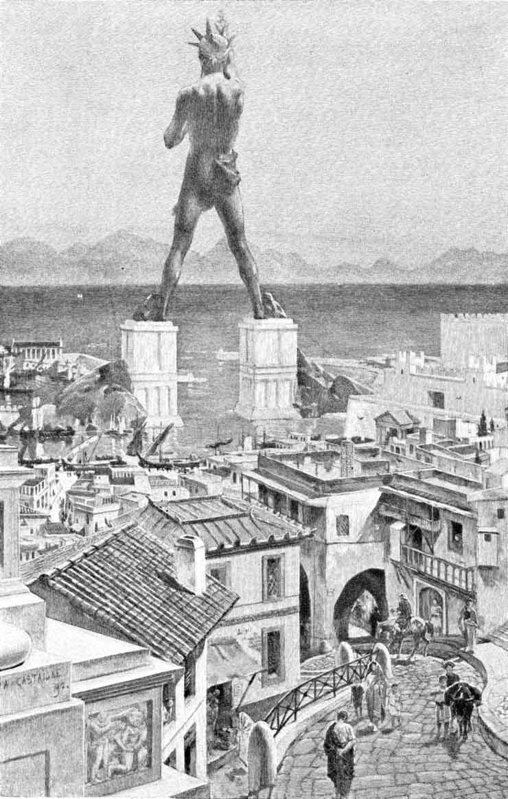
From its building to its destruction lies a time span of merely 56 years. Yet the colossus earned a place in the famous list of Wonders. “But even lying on the ground, it is a marvel”, said Pliny the Elder. The Colossus of Rhodes was not only a gigantic statue. It was rather a symbol of unity of the people who inhabited that beautiful Mediterranean island — Rhodes.
Location
At the entrance of the harbor of the Mediterranean island of Rhodes in Greece.
History
Throughout most of its history, ancient Greece was comprised of city-states which had limited power beyond their boundary. On the small island of Rhodes were three of these: Ialysos, Kamiros, and Lindos. In 408 BC, the cities united to form one territory, with a unified capital, Rhodes. The city thrived commercially and had strong economic ties with their main ally, Ptolemy I Soter of Egypt. In 305 BC, the Antigonids of Macedonia who were also rivals of the Ptolemies, besieged Rhodes in an attempt to break the Rhodo-Egyptian alliance. They could never penetrate the city. When a peace agreement was reached in 304 BC, the Antagonids lifted the siege, leaving a wealth of military equipment behind. To celebrate their unity, the Rhodians sold the equipment and used the money to erect an enormous statue of their sun god, Helios.
The construction of the Colossus took 12 years and was finished in 282 BC. For years, the statue stood at the harbor entrance, until a strong earthquake hit Rhodes about 226 BC. The city was badly damaged, and the Colossus was broken at its weakest point — the knee. The Rhodians received an immediate offer from Ptolemy III Eurgetes of Egypt to cover all restoration costs for the toppled monument. However, an oracle was consulted and forbade the re-erection. Ptolemy’s offer was declined.
For almost a millennium, the statue laid broken in ruins. In AD 654, the Arabs invaded Rhodes. They disassembled the remains of the broken Colossus and sold them to a Jew from Syria. It is said that the fragments had to be transported to Syria on the backs of 900 camels.
Description
Let us first clear a misconception about the appearance of the Colossus. It has long been believed that the Colossus stood in front of the Mandraki harbor, one of many in the city of Rhodes, straddling its entrance. Given the height of the statue and the width of the harbor mouth, this picture is rather impossible than improbable. Moreover, the fallen Colossus would have blocked the harbor entrance. Recent studies suggest that it was erected either on the eastern promontory of the Mandraki harbor, or even further inland. Anyway, it did never straddle the harbor entrance.
The project was commissioned by the Rhodian sculptor Chares of Lindos. To build the statue, his workers cast the outer bronze skin parts. The base was made of white marble, and the feet and ankle of the statue were first fixed. The structure was gradually erected as the bronze form was fortified with an iron and stone framework. To reach the higher parts, an earth ramp was built around the statue and was later removed. When the colossus was finished, it stood about 33 m (110 ft) high. And when it fell, “few people can make their arms meet round the thumb”, wrote Pliny.
Although we do not know the true shape and appearance of the Colossus, modern reconstructions with the statue standing upright are more accurate than older drawings. Although it disappeared from existence, the ancient World Wonder inspired modern artists such as French sculptor Auguste Bartholdi best known by his famous work: The Statue of Liberty.