The Liyobaa Cave Entrances
After the conquest of South America by the Spanish Conquistadores, the Catholic priests who were attempting to convert the heathen Indians discovered a cave entrance to what they called “Hell.” This entrance has since been sealed off with tons of rubble, dirt and huge stones and boulders.
The village of Liyobaa (or to translate it, “The Cavern of Death”) was located in the province of Zapoteca, somewhere near the ancient village of Mictlan, or the “Village of the Underworld.”
The Cavern of Death was actually located in the last chamber of an eight-chamber building or temple. This temple had four rooms above the ground and four more important chambers built below the surface.
The high priests of the then-prevailing Indian religion conducted the ordinary ceremonies for the common man of Theozapotlan in the upper rooms. It was when they descended into the subsurface chambers that the secret and, to them, holy ceremonies, were conducted.
The first underground room was the one which was reserved for any human sacrifice. Its walls were lined with the images of the representations of their various “Gods.” A blood-stained stone altar in the center of the chamber served for the sacrifice of any human victim, whose still-beating heart would be torn from a screaming still-living body and offered to the lips of those same stone idols for their supposed repletion.
There was a second door in the first chamber which led to the second room. This was a crypt where the preserved bodies of all the deceased high priests reposed. The next door in this crypt led to the third underground vault, about the walls of which were the preserved bodies of all the former “Kings” of Theozapotlan. For, on the death of a king, his body was brought to this chamber and installed there with all the state and glory, as well as with many sacrifices to accompany him.
It was from this burial chamber of kings that the fourth and last underground room was accessible. A doorway in third room led into the last underground chamber which seems appropriately to have contained nothing but another entrance covered by a huge stone slab. I write “appropriately,” for the entrance to either HELL or the CAVES should be covered but unencumbered in the area about it for the benefit of those who might wish to leave rapidly and wisely. It was conceived by the Catholic Fathers of that day that this was an entrance to Hades; however, as we may well understand, it was an entrance to a Dero larder.
Through this doorway behind the stone slab were placed the bodies of all human sacrifices as well as the bodies of all the great lords and chieftains of the land who fell in battle. The bodies of those warriors were brought from far and wide to be thrown into this cave when they had been cut down in battles which were constantly being waged by these people.
Many of the common people, when debilitated by an incurable illness or oppressed by an unsupportable hardship, which made them seek death, would prevail upon the high priests to allow them to enter the door of death while still living. They believed that if they did so they would be the recipients of a very special afterlife.
The high priests would sometimes accept them as living sacrifices and after special ceremonies allow them to enter the “Cavern of Death” while still living. Needless to say, none ever returned to describe their experiences.
 The Catholic priests, in order to convert the believers in this “myth” to Christianity, made arrangements to enter this subterranean door with a large retinue of torch holders and a long rope, which was tied to the stone slab door. They also took the precaution of having a large armed guard make sure that the door was not closed on them.
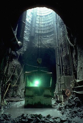
After they had lighted their torches and entered the door, it was discovered that they would have to descend several large steps. At the foot of the steps was a very wide stone-paved passageway with a high stone buttress on either side. The passageway led directly away from the steps into the distant bowels of the earth. The bones of the most recent arrivals, picked clean, lay before them as the passage seemed to continue without end. On each side of the buttressed path they could see into a large area which was a large labyrinth of stone pillars that seemed to hold up the very mountains which they knew they were beneath. As they advanced into the mountain, a putrid, dank air assailed their nostrils, serpents retreated from the light behind the shadows of the pillars in the distance.
They continued into the depths at a distance of about 40 meters when suddenly a strong cold wind began to blow about them. Still striving to continue, as their torches were extinguished rapidly, they took flight when all became dark, not only for the danger of the serpents, but also from strange sounds they could not place, but which were not being made by the members of their own party. Using the rope and the light of the torch one of the guards held in the doorway, out of the strong wind, the entire party rapidly retreated from this terrifying region.
When all the company had swiftly retreated to the ante-chamber of “Hell,” they rapidly replaced the large stone slab door. After this the head prelate gave orders to fill in all the underground chambers and seal off and erase all signs of the stairs to them, thus eradicating for all time this entrance to the Caves.
The Tunnels of South America
In Southern and Central America, as well as in Mexico, the ancient people did not deny the existence of subterranean caves, chambers or tunnels. An examination of the religious beliefs of these ancient civilizations will reveal this.
The Aztecs of Mexico had their dark, dreary and much-feared “Tlaxico” which was ruled by “Mictlan,” their god of death. The Mayas of Yucatan held a belief in the existence of underworlds. These they termed “Mitlan,” and they were icy cold as are most subterranean chambers or tunnels (for proof visit a large cavern in summer clothes and see how uncomfortable you are). These underworlds were presided over by “Ah Puch.” the Lord of Death. We also have mention of the underground in the Mayan sacred writings, the “Popol Vuh”; as well as in the “Book of Chilam of Chumayel.” Even some of the codices seem to refer to them.
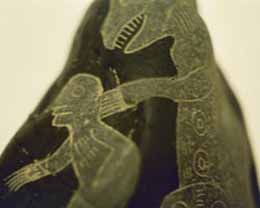
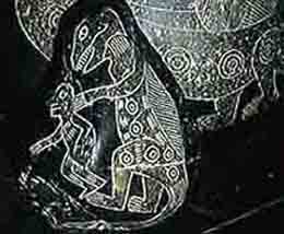
Peru and Chile, when they were ruled by the Incas, also reveal knowledge of the underground. “Supai,” the god of death, had an underground dwelling, a much feared “Place of Darkness .” “Pachacamce,” the god of the earth, caused underground rumblings in subterranean places where huge stones evidently fell, hours after he had shaken the earth with violence.
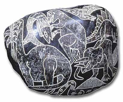
A legend of the first Inca “Manco Capac” relates that he and his followers, the founders of the Inca real, came from underground caves, while the people of the time revered snakes because of “Urcaguay,” the god of the underground treasures. This god is depicted as a large snake whose tail has a hanging pendant from it, the head of a deer and many little gold chains. Even the “Comentarios Reales de los Incas” of Garciliasso de la Vega hints at the existence of the subterranean.
 References to the tunnels have come down to us from information that the Conquistadores obtained. From some unknown source they had gathered information that the wealth of the Inca’s domain was stored in a vast underground tunnel or road, and Pizzaro held the Inca Atahuelpha prisoner in order to obtain his wealth, which, it was rumored, was stored in a vast subterranean tunnel that ran for many miles below the surface of the earth. The Inca, if he had the information regarding the entrance to this tunnel, never revealed it. The priests of the Sun God and the Inca’s wife determined, it is asserted, the eventual fate of the Inca by occult means. The knowledge that Pizzaro did not intend to spare the Inca Atahuelpha’s life caused them to seal up the entrance and hide it so well that it has never been found to this day.
A few Quincha Indians, who are pure descendants of the line of priests, are said to still have the knowledge of the location of the entrance to this tunnel. They are the appointed guardians of this escort, so it is rumored today in Peru.
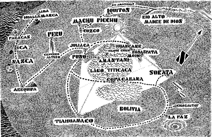
Another source of tunnel information may be a huge monolith of perpendicular rock, which stands apart from its native habitat, the mountains. This rock is of lava, and how it was erected or who erected it is lost in the ages of antiquity, long before the Incas came on the scene. The huge monolith stands alone on the shore of Ila, a small town in the southern tip of Peru, not far from the Chilean border. The rock bears odd hieroglyphic marks carved upon it. Marks which only in the light of the setting sun create a cryptic group of symbols. It is said that these marks will reveal to the person able to read them and decipher the message correctly the location of a secret entrance to the tunnels,an entrance located, some researchers assert, in the fastness of the “Los Tres Picas,” the Three Peaks region. This is a triangular formation of mountain tops near the monolith in the Loa River section.
When Mme. Blavatsky visited Peru, she viewed and concurred with the information regarding the markings on the Ila monolith. She also asserted that information regarding the entrances to the tunnels had been graven in the walls of the “Sun Temple,” at Cusco. Information of a symbolized nature, but nevertheless information which revealed to the person, with the knowledge of the meaning of the symbols, the secret entrance to those tunnels which the priests of the “Sun God” knew about. It is reported that Mme. Blavatsky received a chart of the tunnels, from an old Indian, when she visited Lima. This chart now reposes in the Adyar, India, archives of the Theosophical Society.
 Harold T. Wilkins, author of Mysteries of Ancient South America, also researched and inquired about the tunnels until he was able to conclude the following: Two underground roads leave the vicinity of Lima, Peru. One of these tunnels is a subterranean road to Cusco, almost 400 miles to the east. The other runs underground in a southern direction for more than 900 miles to the vicinity of Salar de Atacama. This is a large salt desert in Chile, the residue of the ocean water which was landlocked during an upheaval of the earth. The upheaval of cataclysm which created Lake Titicaca raised Huanuco high above its place on the shore line. For information about this event, see the section titled “Tiahuanacu in the Andes” of Imanuel Velikovsky’s Earth in Upheaval.
The Cordellarias domeyko, in that section of Chile, very evidently landlocked a great portion of the sea when it was raised. After the sea water evaporated, the vast salt waste, which is almost impossible to traverse, was left.
The tunnel, which has a entrance somewhere in the Los Tres Picos triangle, is also said to have a connection with this long southern underground road.
I conjecture that any continuation of the southern tunnel was broken during the cataclysm, which created the Andes mountain range. Such a continuation would have connected these ancient tunnels with the reputed Rainbow City center in the Antarctic.
I also conjecture that another event may have also happened during a shifting of the earth’s crust at that time. Some of my readers may be familiar with the fact that at least one tribe of Indians in the Southwestern United States has a legend of coming from South America.
This legend relates a story of many years ago. The forefathers of the tribe are said to have lived in a large city far to the south. The story even ties the stars of the sky with the Southern Cross. The town may have been Huanuaca before the earth shift which raised it above sea level. At any rate the legend asserts that the people of this town in the south, the forefathers of a tribe of American Indians, were driven from their homes by a much more hostile and fierce group of warriors. The remnants of those who fled wandered for a long, long time in underground passages which led to the north. These passages eventually led them to our Southwest, where they emerged and set up tribal life once again.
How these ancient Indians were able to see in the dark does not seem to have been taken into consideration. The question of how these ancient tunnels of the Atlan or Titan were illuminated has long been of interest to those who follow the Shaver Mystery. It has long been considered that the tunnels were lit by a type of atomic light.
Steve Brodie is once again a captive of the subterranean people, if he is still alive! I cannot ask him about this, and I regret that it did not come to mind during the all-to-brief period that I knew him many years ago. I do know, however, that he never mentioned any darkness except in relation to the weird outer space pictures he painted. Light is a funny thing: we accept it as our due and never notice it until it is missing. Perhaps some time in the future we may find one of the entrances to the caves and discover just how they are lighted.
The Maltese Cave Entrance
The Maltese Cave entrance is on the island of Malta. This island is the largest of a group of three islands, in the sea that divides Europe from Africa, the Mediterranean. The little Maltese islands lay well off the coast of a much larger island, Sicily, halfway between the Libyan seaport of Tripoli and Calabria of Italy’s Calabrese people who are located in the toe of the bootlike formation of Italy.
 The three Maltese islands are composed of Gozo, Comino and Malta. They represent one of the smallest archipelagoes in the world, survivors of those remote days when continents were of a different shape. Those pre-cataclysm days when Atlantis and Mu may have existed, the days when there was a land bridge between Europe and Africa. Those days when the entire Mediterranean area was merely a series of large lakes.
Malta is the principle island of the three. It reaches a width of almost nine miles, while it is all of 17½ miles in length. Gozo is not as long as Malta is wide and Comino is almost a dot which separates them. Comino has at times boasted of a total population of 50 people.
Malta is the most southern island, 180 miles from the African coast. It was an ancient center of civilization at the time when the Phoenicians from Carthage invaded and began to rule it. At that time blood sacrifice was not new to the Maltese and they readily accepted the priests of Moloch as another name for “Baal,” the Sun or Fire God. These priests offered up human sacrifice to their god, one who rejoiced in the sacrifice of human victims and the outcries of the victims’ parents.
Since the time of the Carthaginians, Malta has had many rulers: Romans, Arabs, Normans, Aragonese, Castilians. Then France ruled the island for a short time before it became the British possession it now is.
However, with all this varied history, and regardless of the many nations who ruled them, the people of those islands still speak the ancient Canaanite, Semitic tongue, the speech of the Phoenicians, and the mother tongue of Queen Dido, who was the founder of Carthage. Malta was the birthplace of Carthage’s most famous citizen, the man who made Rome tremble at the height of his power: Hannibal— of the world’s greatest generals.
On the northeast shore of Malta there are a number of large bays. One of these is known as Grand Harbor. This bay has a point of land extending into it upon which the capital of the Maltese Islands, the city of Valletta, is built. A few miles inland from this town toward the south, overlooking the plain which leads to the shore, is a large plateau known as the Corradino. The little village of Casal Paula is built on this plateau, and from the village one can view Valletta, Grand Harbour, the plain leading to it, and also look out to the sea.
In this small village of Casal Paula during the year 1902 workmen, who were digging a well, literally fell into the earth. They had once again uncovered the outer room of the Maltese Cave entrance. Since the well was to be dug for a house which was on the main street named “Hal Saflieni,” and because this first cave was later discovered to be complex of caves, three of which were a series of chambers excavated out of solid rock on three even lower levels for each chamber, this entrance is known as the “Hypogeum of Hal Saflienti.” A hypogeum is the Latin name for an underground structure.
Later this series of underground rooms was discovered to have been located in the middle of an ancient neolithic village. From the construction of the entrance stones, it is now assumed that at certain times a human sacrifice was chained before the entrance. The entrance and the walls and ceilings of some of the passageways and rooms have been found to be decorated with red ochre primitive art designs, but when first discovered the three caves were crammed with as many as 30,000 skeletons of men, woman, and children. After all these bones were cleared out, the primitive murals were discovered. They took the forms of diamond shapes, as well as oblated and elongated ovals, all of which were joined together with wavy lines and whirls. These decorations had been created solely from the application of red ochre, by the most primitive of methods.
 Once past the entrance, a narrow passageway leads down into the first room. It is in this room, that the “Oracle” may be found. The Oracle is a hemispherical hole in the wall, a which is lower than the mouth of an ordinary-sized man. It is about two feet in diameter, and one can speak into it. A curved projection carved out of the back of the cave then acts as a sounding board. The voice is amplified and caused to resound throughout all the other caves. It creates an effect which must have frightened the primitives into sacrificing many of the members of their tribe to the being who spoke with the “Voice of God.”
If you continue down through the narrow and low passageways, you come to another room. The center of this room has a circular stone altar with runnels on it, the use of which can only be guessed at. Carved in the walls of this room are many niches, the bases of which are like bunk beds. They have hollows scooped out for the heads and bodies, as well as the feet of four-foot-high individuals and some are even smaller.
Leading downward from this room is a small, narrow passageway, ending in another even larger underground room, which has narrow slit-like entrances into other small caves which surround it. One opening, however, is a window into another cave, the entrance to which is covered by a huge slab of stone. This window looks down into what was evidently a prison, but how beings only four feet tall were able to manipulate the huge stone slab must remain a mystery.
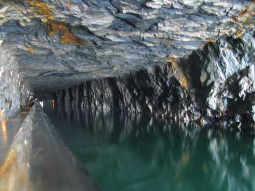
An opening in the wall opposite the entrance to this cave leads to a passage narrow and torturous, the entrance to the real caves. This passage ends on a pathway which extends along the side of a vast cleft in the earth, a pathway along the edge of a veritable chasm, a pathway which leads ever downward to the long underground tunnels and series of caves which are reputed to allow one to traverse the entire length of the island and even further.
 Legend has it that these passageways at one time connected with the underground crypts from which the Catacombs of Rome were created. This may very well be true; for the reader must remember that the Mediterranean Sea was created after neolithic times by earthquakes and the shifting of the earth’s crust. Therefore, while the ancient tunnels may have existed, they might have been closed by cataclysms of this type, with the knowledge of them coming down to us only in legends.
The tunnels under the “Hypogeum” have been sealed off ever since a school teacher took 30 students into the caves and disappeared, guide and all. It was stated that the walls caved in on them. Search parties were never able to locate any trace of these people.
It has been asserted that for weeks the wailing and screaming of children was heard underground in different parts of the island, but no one could locate the source of the sound. If the walls caved in, why the cave-in could not be found and excavated to free the children remains a mystery.
How the children could live to scream for weeks later is another involved puzzle. At any rate, the underground entrance to the caves in Malta has been sealed off, and nobody is allowed to investigate the site.

 Beacon, NY—Just south of the Newburgh-Beacon Bridge lays a
 Dutch settlers when newlywed Polly Pell was saved from the frozen Hudson
 fearless.
 signifying that the captain had returned to make good on his promise.
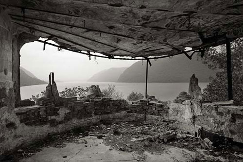 Bannerman’s Island Arsenal has had its share of disastrous events. A